Wicked Yankee is a blog dedicated to all the obscure bits of New England history and folklore that don't often get recorded in history books or taught in history classes.
I recently had the time and opportunity to visit the Jonathan Bourne Historical Center in Bourne, Ma. Visiting the Historical Center allowed me to see a few of their exhibits which I have been meaning to check out for a long time. It also allowed me to see a few I had not known about. Of course these have now peaked my interest and propelled me into future research projects.
The Jonathan Bourne Historical Center is located on 30 Keene Street, in Bourne Ma. The Center itself was built in 1897 by Emily Howland Bourne, who is a descendant of the prolific and regionally important Richard Bourne.
I have written about Richard Bourne several times now, as he was one of the first Christian missionaries to the local Wampanoag tribe and is also connected to the Wampanoag Indian Museum through one of his descendants.
The Historical Center building originally served as a town library. Emily Bourne had the library built in honor of her father, Jonathan Bourne. Jonathan, though a prominent resident of New Bedford at the time, was instrumental in helping the residents of Bourne achieve separation from the town of Sandwich in 1884. Because of his assistance, the new town was named after Jonathan Bourne and the Bourne family.
Bust of Jonathan Bourne at the Historical Center
The building houses the Bourne Historical Society, the Bourne Historical Commission, and the Bourne Archives. Not only does the Historical Center advise the town of Bourne on issues of historical preservation, but it also contains town records like historical maps, photos, family records, oral histories, and historic books through the inclusion of the archives. This makes the center a valuable historic resource in its own right.
The building also houses many interesting exhibits. Among the most famous is the mysterious Bourne Stone, which I will be researching for a post in the very near future. However, their largest and most current exhibit is a display containing posters and artifacts from both the First and Second World Wars.
WWI and WWII Posters and Artifacts
This exhibit not only contains several interesting propaganda posters from the allied persepctive, but also contains a display which details information on the military career of Sergeant Stubby, the most decorated war dog of World War I. Although he appears to be an early Boston Terrier type, his true breed appears to have been unknown. However, he did originate in Connecticut, which makes him a Yankee, and worthy of a more detailed post in the near future.
Stubby the War Dog
An additional exhibit which caught my attention was on one of the few serial killers to grace the shores of Cape Cod. Nicknamed Jolly Jane, she was reportedly responsible for the deaths of nearly every member of an entire family.
Jolly Jane's Exhibit
While visiting the Historic Center, I drove a couple miles down the road to check out the recreation of the Aptuxet Trading Post. The building sits on the foundation of what is thought to be the original 1627 trading post, which once sat alongside the Manamet River. The original course of the river was incorporated into the digging of the Cape Cod Canal. The current museum is a recreation of what the post was thought to have looked like.
Aptuxet Trading Post Museum
The Jonathan Bourne Historical Center is open Mondays and Tuesdays 9am to 2:30pm. It is also open the second and fourth Wednesday of the month from 6:30pm to 8:30pm.
I had a great time visiting the Bourne Historical Center and the Aptuxet Trading Pos Museum.. Not only did I once again visit a museum dedicated to local history, but I learned several new things and was inspired to continue learning about what I saw. To me, that’s what its all about. As I’ve said, during the next few weeks, I hope to continue researching the Bourne Stone, Jolly Jane, and Stubby the war dog in order to create detailed posts about each.
Until then, if you are in the area, take time to visit the Jonathon Bourne Historical Center for yourself. It’s a great opportunity to admire objects and exhibits dedicated to some of the odder, more mysterious, and less well known subjects within New England History. In addition, it is a great example of how important smaller local museums are to the continued effort to preserve an archive our Yankee heritage for posterity.
If you have even walked by a TV news broadcast, tuned into the news on your radio, or glanced at an online headline you have most likely heard that a man has most likely been attacked by a shark off Ballston Beach in Truro, Ma. This is certainly not the first shark attack to occur in New England waters. In fact, it might not even be the first in recent memory.
According to several news stories, including this one from the Huffington Post, Chris Myers was body surfing with his son about a third of a mile off Ballston Beach Monday afternoon, when he was pulled under by a shark. JJ Myers, the son of the victim, heard his father scream and saw what he described as the back of the shark and its dorsal fin. Mr. Myers and his son swam quickly back to the shore where 911 was called.
Chris Myers suffered serious wounds below the knees on both legs. After being pulled from the water Myers was transported to Mass General Hospital in Boston. Although it was originally uncertain whether this was a shark attack at all, a Massachusetts Marine biologist named Greg Skomal later stated that he believed the injuries Myers suffered could only have been caused by a Great White.
Myrers underwent surgery on Tuesday to repair a severed tendon, but felt strong enough to interview with Good Morning America, where he discussed his ordeal in detail.
The whole story seems pretty scary to me, as I grew up swimming in the waters off Cape Cod. However, it also made me curious about the history of shark attacks in New England. I was not surprised to find that several historic news sources indicate that shark attacks are not unknown in this region, but I was pleased to find that they are seemingly quite rare.
Many news stories over the past week are reporting that before Chris Myers, the most recent shark attack in New England occurred in July of 1936 in the town of Mattapoisett. In some respects this is correct. The attack that occurred in Mattapoisett in 1936 was the last reported fatal shark attack of record in New England.
According to a 1936 article in the Boston Herald, a sixteen year old boy named Joseph C. Troy was attacked by what was probably a Great White while swimming about a 100 yards off Hollywood Beach in Mattapoisett. Troy had been swimming with a friend of his uncle named Walter Stiles. Stiles reported to the Herald that he saw the fin of the shark cut through the water toward Troy. He saw Troy attempt to fight the shark off when both the boy and the shark disappeared below the water. Stiles swam toward the shark and the boy and attempted to dive in an effort to recover the child. However, Troy eventually popped up to the surface unconscious.
Boston Herald article 1934
Stiles attempted to signal fisherman who were close by, but failing to do so, began to swim toward the shore carrying Joseph Troy. Eventually the two were pulled on board a passing boat. When Joseph Troy was pulled aboard it was noticed that his left leg had been badly injured during the attack. Apparently a chunk of flesh about the size of a five pound roast beef was missing. Doctors later attempted to amputate the injured leg in an attempt to save the boy’s life at St. Luke’s Hospital. However, Joseph C. Troy died of his injuries around 8:30 that night.
According to the website New England Sharks, the animal responsible for the 1936 Massachusetts attack was reportedly 10-12 feet long. Although it was never identified officially, the descriptions of the shark given by Stiles (whose name was misspelled in the article) most closely match that of a Great White.
An additional shark attack occurred in July of 1830 in Swampscott, Ma. According to an article in the 1830 Salem Register, the victim was a 52 year old man named Joseph Blarney. Blarney was fishing in a small dorey for several hours, when he was seen waving his hat in the air and calling for help. A ship near Blarney attempted to come to his aid when the dorey and Mr. Blarney were both attacked by what was assumed to be a shark. Blarney, as well as his small boat, disappeared below the water. The boat eventually resurfaced, but Blarney never did.
1830 fatal shark attack
New England Sharks reports that there was at least one other fatal shark attack which occurred in Boston harbor around the year 1730. However, I could not find records describing this attack.
Strangely enough the Cape Cod Times reported this morning that the fatal shark attack of 1936 was potentially not the most recent attack in New England waters. The article titled, Past Cape Shark attack victim says he feels vindicated, describes the 1996 experience of James Orlowski of South Hadley. Orlowski was collecting starfish in Truro in waist deep water, when what he claims was a six foot shark attacked his leg. Apparently Orlowski needed several stitches to repair the damage to his ankle. In addition, Orlowski experienced serious infection related to the injury. However, his story was doubted by authorities at the time. Investigators informed him that sharks do not frequent the waters of Truro, which we now know is false. The article speculates that there could be several more injuries due to shark attacks that simply went unreported.
This summer there have been many sharks spotted along the shores of Cape Cod. Many people have stated that the quickly recovering Gray Seal population around the "elbow" of the Cape is now attracting Great Whites to this area. Many marine biologists like Greg Skomal are excited to have the opportunity to study Great Whites more carefully. I don’t blame them, it’s interesting. It is like getting the opportunity to study a tiger or lion up close.
It has been speculated by some biologists that Great Whites attack humans when we are mistaken for seals or sea lions. This is potentially true in the case of Chris Myers who suffered serious wounds in his attack, but exited the water with all limbs and his life intact. The shark seemingly bit him and decided to move on. However, in the historic shark attacks of New England’s past, the victims were not as lucky.
Although I live on Cape Cod, there are not many seals in my area. Nor have there been any shark sightings in my area. However, I must admit, I would rather not swim far from shore alone. Certainly when I do swim, visions of a large predatory shadow gliding my way pop into my head frequently.
As New Englanders, we have grown up with the Atlantic as our backyard. We quahog, fish, and just relax in the shores of our home towns. However, when we do this, we must also remember we are entering the fringes of another world. One we are not well adapted to surviving in. Like our Yankee ancestors must have known, entering the ocean is like walking into the dense tree line of an unexplored tropical jungle. Much like New England itself, you just never know what might be lurking in the shadows or just out of sight.
In the past few weeks there have been several updates in regards to information pertaining to the mysterious origins of Native Americans. Although, as usual, the new information is not definitive, it seemingly adds new possibilities which researchers will now attempt to evaluate in comparison to existing theory.
The first piece of interesting information is that researchers now believe that Native Americans did not originate as a result of one single migration from Asia, but most likely stemmed from at least three. The research, described in Popular Archaeology, states that an international team led by Professor Andres Ruiz-Linares of the University of College London and Professor David Reich of the Harvard Medical school, have come to this conclusion after comparing the DNA of 52 Native American and 17 Siberian groups. All together, the team analyzed over 300,000 DNA sequences.
However, the team also found that the majority of natives descend from only the original migrants across Beringia over 15,000 years ago. In fact, only native groups that live in arctic regions and speak either Eskimo-Aleut or Na-Dene languages felt any genetic effect from the second and third migration across the Bering Land Bridge. Though these groups are more closely related to modern East Asian populations, the arctic groups still derive between 50% and 90% of the DNA from the first migrants. This suggests a genetic mixing between all three migrant groups.
Beringia
In addition, researchers were able to trace the potential genetic path followed by the original migrant group. After their arrival, the first group traveled south along the coast, splitting into separate population groups as they traveled into South America.
However, DNA suggests that there was some reverse migration among these groups. Some native populations in Central America show genetic traits of both North and South American groups. In addition, some Eastern Siberian populations show Native American traits that could only have occurred if established native populations reversed their path back across the Bering Land Bridge to mix their genes with Asian populations.
The second recent study regarding the origins of Native Americans has less to do with DNA and more to do with human artifacts. For many years those who believed that North American natives descend from a single migration from Asia also believed that this single migrant groups was most likely what archaeologists call the Clovis Culture.
Clovis Culture is defined by the presence of a distinctive type of stone tools like projectile points. This type was first discovered in New Mexico in the 1920’s and 1930’s. Radiocarbon dating has placed the arrival of the Clovis Culture from Siberia to approximately 13,000 years ago. For decades many theorists have believed that all natives in North, Central, and South America descend from Clovis groups and perhaps a single migration of people. However, more and more often, this is no longer thought to be the case.
Aside from the study referenced above, some of the most intriguing evidence building a case for the multiple migration theory is coming out of Paisley Caves in South-central Oregon. Although this set of caves have been studied since the 1930’s, recently archaeologists have uncovered what many believe could be pre-Clovis human artifacts.
What researchers have found are over a hundred examples of what is called Western Stemmed projectile points, a style of stone tool which differs significantly from the Clovis tradition. In addition, archaeologists have analyzed examples of dried human feces called coprolites. What is missing from the cave system is the presence of any Clovis artifacts.
The bases of three Western Stemmed projectile points
According to an article from Archaeology Daily News, the Paisley artifacts radiocarbon date to at least 13,200 years ago. If this analysis is correct, the Paisley artifacts would either pre-date or would have been contemporary with Clovis culture. Although the ancient DNA taken from the coprolites show an east Asian or Siberian origin, because the tool making traditions are so different, this evidence would also suggest the presence of two separate groups in ancient America.
In fact, researchers associated with the University of Oregon have postulated that the people of the Western Stemmed tradition may have descended from a separate migration that took place along a sea route, following the coast of ancient Beringia. Researchers also suggest that the Clovis culture may have first arisen in the Southeastern US, then moved west. However, the Western Stemmed tradition might have begun in the West and might have moved east from there. Both traditions would have remained separate for hundreds of years.
One of the interesting things I see when comparing these two studies is that they seemingly explain multiple migrations that are even separate from one another. The DNA study shows three separate migrations, but states that the DNA contributions of migrations two and three were limited to the very arctic regions of North America. However, the Paisley Caves study seems to have uncovered a population descended from a completely independent migration that existed apart from arctic regions. The studies don’t necessarily contradict each other. Rather, each suggests that there is more to the origins of Native Americans than we currently understand. Considering how much has changed in Native American origin theory in the last year, I can't wait to see what the next year of research brings us and potentially how this might impact what we believe about the origins of natives in New England.
I recently had the opportunity to visit the MashpeeWampanoagIndianMuseum. This was a great opportunity for me to learn more about the Mashpee Wampanoag tribe and an opportunity for me to ask some of the questions I’ve accumulated during my own research regarding the Wampanoag tribe.
The museum is located at 414 Main Street (Rt. 130), Mashpee. The house containing the museum was built around 1793. It was originally the home of Sherjashub Bourne, the great-grandson of the famous Richard Bourne.
The Bourne-Avant House- Rt. 130 Mashpee
I had stumbled across several Richard Bourne related legends when I attempted to trace the history of Chamber Rock in Bourndale. Richard Bourne was one of the first Christian missionaries to preach to the Cape Cod Natives. He also purchased huge areas of land on Cape Cod and set the land aside for the tribe he called the South Sea Indians. This land eventually became part of the Town of Mashpee.
The current curator of the museum is named Putnam Peters, himself a member of the Wampanoag tribe. As he led our small tour group through the building’s displays, he was patient enough to answer my many specific questions.
Putnam Peters- Curator of the Museum
Putnam explained the current members of the Wampanoag tribe still revere Richard Bourne. In fact, the tribe celebrates a Richard Bourne Day every year. Putnam was also able to answer a lingering question I had about the story of Chamber Rock, in which the Wampanoag had been performing human sacrifice. Putnam stated that he had never heard any history to support such a practice.
Putnam and his wife Jeanne were also happy to discuss Metacom, Massasoit, and the King Philip’s War. They also showed me a wall in the museum which displayed the current leadership among the Wampanoag Tribe. I would have to say that both Putnam and Jeanne were very knowledgeable about their subject.
The current Chief, Sachem, and Medicine Man of the Wampanoag
If you are interested in visiting the WampanoagIndianMuseum, it is open every Monday and Thursday from 10am to 2pm. There is no entrance fee, but there is a place to make a donation to the museum. As the building is currently under renovation, I’m sure a donation would be appreciated.
Museums like this are really important. Not only do they display one of a kind artifacts, but they help maintain and educate people about local history which is not something that is taught in every classroom. Putnam and Jeanne explained that they often have very young children visit the museum during the school year, which is a great educational opportunity for them.
Some of the original Wampaoag artifacts on display
A display showing how pre-Columbian Wampanoag would harvest trees
However, the history of the Wampanoag people, the King Philip’s War, and the development of New England is a huge and mature subject for such young children to learn about. Museums like this bring this history to a larger audience, who might become curious about something they learned. Maybe they’ll embrace their curiosity and delve into some research. And as I’ve learned, one answered question only leads to more. Embrace that, and sometimes the learning and curiosity goes well beyond the museum door.
Yankee Doodle is a song most American school children learn sometime between the ages of 5 and 8. Most adults recognize the song, if not all the lyrics. I hope that most people probably know that, at least in legend, the song and phrase “Yankee Doodle” were both created by the English to be derogatory and insulting to Americans.
By examining the common lyrics, it’s not difficult to see the slight. Even the version school children learn is a little insulting. It reads:
Yankee Doodle went to town,
Riding on a Pony;
He stuck a feather in his cap,
And called it macaroni.
On my first post on this blog, I attempted to trace the meaning of the very complicated term “Yankee.” Although, no one really knows its exact origins, it essentially refers to someone of New England. The term “Doodle” is easier to understand. It simply means something like idiot, half-wit, or simpleton. As in all the many versions of this song, the term Yankee Doodle is synonymous with a country bumpkin, or what some would call a “hick.”
The entire scene these first four lines paint is of someone who is simple and uneducated. He rides on a pony instead of a horse. When he calls his feathered cap macaroni, he is not referring to the pasta, but rather to a fashion popular in England during the mid 18th century. A Macaroni was someone who dressed and acted at the extremes of fashion, often to the point of being somewhat ridiculous. The term is actually related to the Italian pasta (oddly), because eating macaroni was fashionable for well traveled European men of the 18th century. These rich young men would describe fashionable things as being extremely “macaroni.” In fact, they belonged to a group popularly known as the Macaroni Club.
One of these very Macaroni styles was wearing an extremely tall powdered wig topped by a small hat which could only be removed with a pole. These guys seem somewhat like our 20th century “metro-sexual.” Fashion, hygiene, and popular trends were identity defining among these men. In fact other English of the 18th century made use of the macaroni style in satire. However, in Yankee Doodle, the line is used to suggest that this Yankee is so simple he actually believes putting a feather in his plain old cap equals the extremes of European fashion.
According to legend, British troops created the lyrics during the French and Indian War between 1754 and 1763 to describe their under-trained, uneducated, home-spun colonial allies. Several prominent Americans like Benjamin Franklin even tried to play up to this character while in Europe during the Revolution by dressing in animal furs and acting as if he were from the extreme frontier. Apparently, this is what many Europeans expected colonial Americans to look like.
It’s interesting that this little anthem turned from being a derogatory insult into a national ballad of pride. In fact, it is said the tune was played so much during the Civil War that General Grant admitted he only knew two songs. The first was Yankee Doodle, he said, and the second one wasn’t.
However, as with most things in history, the origins of the lyrics and the tune are cloudy. Even how the song switched sides during the Revolution is a little murky. However, the two schools of thought point to either an English or an American origin for the song. Hence, whether it was truly originally created to be used to insult the colonials is even in question.
In his book Liberty and Freedom, David Hackett Fischer argues that the legend is correct. Yankee Doodle was a song created by an Englishman targeting colonial Yankees for their backward ways. In fact, he credits Dr. Richard Shuckburgh, an English surgeon stationed in New York during the French and Indian War, with the creation of the tune and certain lines.
During the French and Indian War, British regular troops were shipped over the Atlantic to protect the original American colonies from the French and their Native American allies. Of course, they were not doing this out of kindness or concern. Great Britain was mostly acting out of self interest by protecting their profitable colonial territories from a rival European power.
Hackett explains, according to the records of three New York families, the lines of Yankee Doodle written by Shuckburgh between 1759 and 1760 while he was stationed in Albany. Hackett States:
“The Regulars laughed at the antics of the Yankee militia. Their quaint clothing, curious speech, and clumsy manners became the butt of British humor.”
One must understand that the early colonies were very agricultural and rural. Though Yankees could be fierce warriors, they were very different than British regulars. Colonials were more used to irregular guerilla warfare and scouting, if experienced in warfare at all. They did not all have uniform clothing, weapons, or training. Each colonial area provided what they could to their militia. Among these provisions would have been odd assortments of hunting rifles, few bayonets, and perhaps scraps of military dress. Obviously most Yankees were more used to shooting rabbits, deer, and squirrels, than enemy soldiers.
Assembled as a whole in Albany, the New England militias must have looked like a rag-tag, back woods, odd looking, sounding, and probably smelling collection of provincials. In fact, from the prospective of the British, they probably were.
Though Hackett states it is quite possible Shuckburgh penned the verse of Yankee Doodle we all know so well, in The Story of Our National Ballads, CA Browne argues that the original opening verse was probably different. Set to the tune of an old English country dance, Shuckburgh might have actually written:
Father and I went down to camp,
Along with Captain Gooding.
There we see the men and boys,
As thick as hasty pudding.
Apparently, Shuckburgh attempted to convince the colonial leaders that the song was a well respected military tune in England. Though, the regulars knew this was a joke, the colonials took up the song as their own. According to Browne, the song called at that time “The Yankee’s Return to Camp” found constant use in the militia camps. Of course the British, including Shuckburgh, must have thought this was hilarious.
However, this is somewhat disappointing. This means the most well known verse containing the pony, feather, cap, and macaroni was not the original. In fact, Roger Lee Hall, author of The Boston Yankee Ballad writes that this version does not show up in print until 1884 in a book entitled The Nursery Rhymes of England. Though, he also quotes author James J. Fuld, who explains that most authorities now believe the song was of American origin.
In fact, Hall quotes the author of Music for Patriots, Politicians, and Presidents, who states that the original verses of Yankee Doodle can actually be attributed to a sophomore at HarvardUniversity named Edward Bangs. Edward served as a minuteman at the Battle of Lexington. The verses Edward Bangs wrote were printed in a popular broadside, which was created between 1775 and 1776. Hall records Edward’s original lyrics as being:
Father and I went down to camp,
Along with Captain Gooding.
There we see the men and boys,
As thick as hasty pudding.
Chorus:
Yankey doodle keep it up,
Yankey doodle dandy,
Mind the music and the step,
And with the girls be handy.
Hall does not discount that Shuckburgh may have had a hand in the creation of Yankee Doodle. However, he states that it was not until the version created by Edward Bangs was printed that this song became popular. In addition, he states that the Bangs version would have been the most well known during the Revolution.
The broadside and lyrics attributed to Edward Bangs
It is now unclear whether the song was originally created by the British or the Americans. However, as the animosities created during the French and Indian War led to the conflicts which began the American Revolution, Yankee Doodle was being used as a morale lowering weapon. According to CA Browne, British troops occupying Boston prior to the massacre in 1770 were already playing Yankee Doodle to annoy and harass the Bostonians. They even played it outside colonial church services and aboard British ships anchored Boston harbor. Browne even goes so far as to state that the British marched out of Boston to reinforce their forces at the Battle of Lexington to the tune of Yankee Doodle.
It seems the song finally switched sides after the Battle of Bunker Hill in 1775. Thomas Aubrey, a British officer during the Revolution, writes about this transition in his series of letters entitled Travels Through the Interior Parts of America.
In his writing, Aubrey claims that the term Yankee was originally created by the Cherokee to mean coward, though this is only one of many theories. He said that the soldiers stationed in Boston during the commencement of hostilities often used the term as an insult. However, he also writes:
“But after the affair of Bunker Hill, the Americans glorified in it. Yankey-doodle is now their paean, a favorite or favorites, played in their army, esteemed as warlike as the Grenadier’s March – it is the lover’s spell, the nurse’s lullaby. After our rapid successes, we held the Yankees in great contempt; but it was not a little mortifying to hear them play this tune, when their army marched down to our surrender.”
Though the colonial militia lost the Battle of Bunker Hill, Aubrey is probably referencing the 1781 British surrender at Yorktown, Virginia. General Cornwallis, claiming illness, refused to ride out and surrender his sword to General Washington. He had his second in command deliver the weapon is his stead. Even then, it was delivered first to the wrong man.
As the British officers and German mercenaries marched by the assembled American and French leaders, the British refused to salute the colonial generals and commanders. Washington had ordered the army to remain courteous in victory. The English band played an old song called, “The World Turned Upside Down.” In response, as Aubrey stated, the Continental army responded with Yankee Doodle. It was the old morale-busting weapon of the British now turned against them.
If Dr. Shuckburgh did invent the lyrics to Yankee Doodle, he did not live to see how his song would be used or what it would eventually become. The tune changed in both lyrics and meaning as the French and Indian War led to the American war for independence. Even if most of the known lyrics were written later by Americans, the song and term “Yankee Doodle” changed from colonial insult to national ballad as Americans embraced the peculiar, awkward, somewhat provincial, yet entirely independent character the song describes.
Even though Yankee Doodle no longer really holds its position as the “in your face” patriotic theme it once was, from my perspective I find it amazing that it has survived in any form in our blind-to-our-past modern American culture. Though we still sing the song to our children, I wonder if most people know the significance of the words, how they were directed, and eventually how they were used. I cringe a little as it sometimes seems hard to find that independent Yankee Doodle character represented in our 21st Century national identity. As I mentally scan through TV channels, news broadcasts, newspapers, the internet, and other forms of poplar media; It immediately becomes clear, perhaps we are now confused as to who is the Yankee and who is the Macaroni.
I’m a little disappointed that I did not find this awesome CapeCast video until after I finished researching Follins Pond and Leif Ericson. I know this area well and I could have found the Blue Rock, which seems to have an example of what was considered by some to be a mooring hole. However, this video also expresses doubt that these holes were created by Norseman. When I get my kayak up in this area in the near future, I will get my own photos of BassRiver’s Blue Rock. Until then, enjoy the video.
Throughout New England there are many sites and archeological finds which seem to suggest that Norse dragon ships, along with their European passengers, may have arrived in the North East of the United States about 500 years before Columbus accidentally landed in the Caribbean. Though, the majority of these finds remain categorized as mere curiosities, there are several that suggest history books concerning the subject of the discovery of the New World should be re-written.
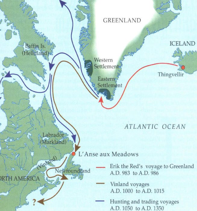
Information of possible Norse exploration comes from very few historical sources. In fact, the majority of the information comes from the Norse Sagas, including The Saga of Eric the Red and The Saga of the Greenlanders. Although the sagas depict events that took place around 1000 AD, they were not committed to writing until the 13th century. According to the sagas, the story begins with Eric the Red, an Icelander who was banished from Iceland for manslaughter around 982 AD. During his banishment, Eric explored and settled Greenland.
Eric the Red
The Sagas give two versions of how land was discovered west of Greenland. In one version, it seems that the son of Eric the Red, known as Leif Ericson, first sighted new land while sailing to Iceland in order to spread Christianity. However, the second version states that in 985, a Norseman named Bjarni was sailing from Iceland to Greenland. He was blown off course, only to find himself near the coast of an unknown land. After skirting the shores of several strange areas, Bjarni eventually arrived safely in Greenland at this father’s settlement. According to the Saga of the Greenlanders, he never sailed again. However, he did report what he had seen to Leif Ericson.
Leif Ericson by Christian King
The tale goes on to say that Leif purchased Bjarni’s ship and gathered adventurers to sail west in an attempt to locate this new land. Eric the Red was about to join his son on the expedition when he apparently fell off his horse, injuring himself. He saw this as a bad omen and declined to join Leif and his crew.
Leif followed Bjarni’s directions west and first landed on a flat rocky shore, he called Helluland, which means appropriately “Land of Flat Stones.” Most researchers agree that this was most likely Baffin Island, which is the largest island in Canada. Though, some also suggest that it might have been north Labrador. Though Ericson interacted with the natives on the island, whom the Norse called skraelings, he ultimately decided not to settle in Helluland because it was inhospitable.
Traveling further, Erikson and his crew landed in a forested area which he called Markland. In Old Norse, the name means “Forestland.” Again, there is agreement that this was probably Labrador. Later the Greenlanders used this area to gather timber.
Leif Ericson continued to sail south for two more days. He next arrived at a place he called Vinland, which is generally translated as “WineLand” or “MeadowLand.” Here the Saga of the Greenlanders describes how Ericson sailed west past a Cape and entered a large river, which connected to a lake. The saga further states that this land was warm enough to allow their cattle to graze outside throughout the winter months. Ultimately, Leif Ericson decided to spend the winter in Vinland. He created a small settlement called Leifsbudir.
Map showing possible Norse routes
In the spring, Leif returned to Greenland carrying a cargo of grapes, grape vines, and timber. His brother as well as other Norse adventurers later explored the same areas, sometimes fighting and sometimes trading with the natives there. They used Gaelic runners to explore three days over land. The runners returned with more grapes and wheat. There are at least two other historical references to Vinland, aside from semi-legendary Norse Sagas. One source even predates at least the writing of the Norse Sagas.
There have been many theories presented which seek to match Vinland with a modern location. In 1960, a Norse settlement was discovered on the northern tip of Newfoundland. Many believe that this area, called L’Anse aux Meadows, is probably Leif Erikson’s camp. However, it has also been theorized that Vinland may have been a very large area, including at least three small settlements, the Newfoundland site being one of them.
As I said, there are probably hundreds of artifacts and unexplained pre-Columbian sites which claim Norse origins. I have plans to visit several of them as seasonal museums begin to open. However, Follins Pond, in the towns of Dennis and Yarmouth, is somewhat unique among these sites. Unlike many artifacts and areas people claim a Norse connection to, the Follins pond area has been at least researched by professional archeologists and historians. Some of these researchers even came to the conclusion that the shore Follins Pond was actually Leif Ericson’s camp in Vinland.
Most of the evidence supporting a Norse visit to Follins Pond can be attributed to research conducted by the former writer, teacher, and amateur archeologist Frederick J. Pohl. Pohl believed that Leif Ericson entered the mouth of BassRiver in Cape Cod, traveled several miles up the river, and ultimately camped on the shores of Follins. Certainly the area is reminiscent of the description of Vinland in the Norse Sagas.
In 1952, the Massachusetts Archeological Society (MAS) conducted digs in the areas of Follins Pond most suspected of Norse visitation. In the January 1953 Bulletin of the Massachusetts Archeological Society, Benjamin L. Smith, outlined the work conducted by the MAS in an article entitled A Report on the Follins Pond Investigation.
According to Smith, several interesting things were discovered during the dig which some believed were suggestive of a Norse presence. The first piece of controversial evidence included several buried wooden posts and stones, potentially used to support a shored ship. In addition, the wood seemed to have been shaped by a metal axe. Yet, members of the Archeological Society estimated that the wood and construction was no more than 90 – 150 years old because the wood was not completely rotted. They theorized that the ship might have been a colonial ship hidden from the British during the War of 1812 or the Revolutionary War. In addition, they were informed by local historians that the area in which the posts were discovered was once used by Cape fisherman as a boat landing.
However, in the 1955 article entitled Comments on the Follins Pond Report, Pohl expressed his disagreement with the findings of the MAS. He stated that the shape, size, and estimated weight of the construction of wooden posts and stones suggested the shape of a classic Norse ship. He also suggested that the wood might have been well preserved by having been buried several feet under the shore bank immersed in an oxygen deprived environment. Therefore, the wood might be centuries older than it appeared.
Map of the Follins Pond digs- MAS
In addition, another piece of evidence Frederick Pohl suggested as proof of a Norse visitation to Cape Cod were the existence of what he called “Mooring Holes” in several rocks along the shore of the Follins Pond and Bass River. According to Pohl, these holes were drilled manually into rocks always at a slight angle. In these rocks would be placed a large iron pin with an eye-hole, which attached the ship to shore by use of ropes. These were of particular interest to Pohl because similar holes have been discovered in more classically Norse areas like the fjords of Scandinavia.
Furthermore, some of these holes seemingly presented with specific characteristics which the “mooring holes” of Norse Europe would have displayed. For instance, some of the holes on Cape Cod were slightly triangular in shape, with bulging, rounded sides. To Pohl this indicated that they were chiseled by hand, rather than drilled mechanically.
However, the MAS also responded to this evidence in their original report. Smith suggested that most of the holes were drilled for the purpose of blasting the nearby rocks with explosives. The rocks were then used to create the breakwater at the mouth of BassRiver. Furthermore, researchers from the MAS found that a type of drill widely used in the 19th century Cape also left triangular shaped holes with wide bulging sides. Therefore, even if the holes were mooring holes, there was no way to tell when they were created.
Large rocks along Follins Pond
In his 1953 article, Frederick Pohl defended his theory concerning the mooring holes. He conceded that he may not know exactly when the mooring holes were bored into the rocks along Follins Pond, but was sure that they were not holes intended for blasting rock used in the construction of the Bass River Breakwater. He stated that such holes would have been larger, more circular, and there would have needed to be several holes per large rock.
However, the existence of odd holes and the remnants of a shored boat were not the only pieces of evidence discovered to support Ericson’s visit to the Cape. In an article entitled An Osseous Find at Follins Pond, an archeologist named Bernard W. Powell reported his findings after having examined a domestic horse bone found near Follins. The bone was discovered by a local home owner. Powell explained that the remains of domestic horses are present in the Greenland settlements, though rare. Hence, it would be plausible that the Norse who might have explored the Cape might also have been in the company of horses. Unfortunately Powell could not determine the age of the bone. He suggested that the potential weight of the animal belonging to the bone might be of a weight comparative to Norse domestic horses, but not much else could be determined. Hence, this piece of evidence, like the mooring holes and remains of the shored boat, are simply circumstantial.
In my short exploration of the Follins Pond area, my fiancé and I were able to see how the pond easily connects to BassRiver, and from BassRiver to Nantucket Sound. Assuming it looked similar in 1000Ad, a 60 foot Viking ship could make the trip from the sound to the pond.
Bass River from Bass River Bridge- May 2012
However, we were ultimately unable to get close to any large rocks along the shore which could have been examples of Pohl’s mooring stones. The shore of the pond is covered with private beaches and back yards of private properties. There are very few public access areas along the pond, and none have large stones near them that we could see. We could not get very close to the area called the “gully,” which is displayed on the map of Follins created by the MAS. This was the spot at which the remains of the ship was discovered. However, I was able to take several pictures of this area from across the pond at a public boat landing, but I would have liked to poke around there myself. Maybe I can return to this area with my kayak sometime this summer and attempt to locate some of the areas displayed on the map without having to trespass.
The Gully area from a distance
Remains of a shored ship was unearthed here
So it seems that the mystery of the modern location of Ericson’s Vinland remains unsolved. It might have been the small Norse settlement discovered in Newfoundland, but it might yet be an area south of that. Its possible it could still be along the shores of Cape Cod. Pohl certainly believed it was, even refusing to accept the conclusions of the MAS investigation.
However, after reviewing the evidence supporting Pohl’s Follins Pond theory, I have to admit that there is some evidence suggesting a thousand year old Norse visitation, but there is not enough to conclusively say Ericson and his explorers were ever here. This, however, does not seem to matter to the residents of Dennis and Yarmouth. Many of the roads surrounding Follins Pond have classic Viking names like Norse Road, Saga Road, Vinland Drive, and Leif Ericson Drive.
Whether or not any evidence will ever prove the Cape’s association with Ericson’s Vinland is pretty dubious. Archeologist, Bernard Powell, thoroughly explained why it is so difficult to locate proof of a small thousand year old Norse settlement (as if an explanation was needed). In his article The Mooring Hole Problem in Long Island Sound, Powell discusses the research conducted by Pohl. He mentions that Native Americans have lived in the Northeast in substantial numbers for thousands of years and very often archeologists come up with no proof of their habitation in places where researchers know they lived and worked. Imagine then, attempting to find the camps of only about 300 Norseman who might have journeyed to Vinland a thousand year ago for only one or two summers. Not only is it improbable, but it seems mindblowingly impossible to be able to locate absolute proof.
Still, as I mentioned, there are several Norse related curiosities throughout New England, other than the evidence discovered at Follins Pond. These oddly built structures and puzzling artifacts like Dighton Rock, the Bourne Stone, and America’s Stonehenge hint at the possibility of some unknown presence mingling with the Native tribes and cultures of ancient New England. However, I could not say if these were the works of Leif Ericson and his crew. Yet, certainly the possibility exists, and should not yet be dismissed, that a thousand years ago, dragon-prowed Viking longships once slipped from the primordial New England mists to leave their mark somewhere on our Yankee shores.