Showing posts with label Vikings. Show all posts

Wednesday, November 21, 2012

New Evidence of a Canadian Viking Outpost


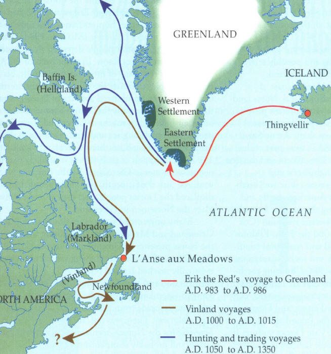
Map of possible Norse exploration routes
 Historians and archaeologists have long since believed Nose explorers visited the east coast of North America around 1000 AD. Certainly this blog has focused on several pieces of New England history in which this has been one of the working theories. However, for fifty years the only evidence of the presence of the Northmen has been the discovery of the temporary camp called L’Anse aux Meadows in Newfoundland.
Recreated norse longhouse at L'Anse aux Meadows
Still, as I discovered when researching the theory behind Ericson’s supposed camp on Follins Pond, the Norse had described at least three lands during heir journeys west of Greenland. First Ericson described Helluland, or the land of stones. Second, he described Markland, so named because it was covered in forestland. The last land he described, he named Vinland, which could mean either "Wineland" or "Meadowland."

Although following the course of Ericson’s exploration on modern maps has not been really useful, many people have posed the theory that Helluland could actually be Baffin Island, which is immediately west of Greenland. Yet, until this year no proof had been discovered to support this hypothesis.

Earlier this fall, a professor of archaeology associated with Newfoundland’s Memorial University named Patricia Sutherland made significant new discoveries while excavating a centuries old building on Baffin Islands. According to National Geographic, Sutherland’s team uncovered several whetstones. What made these stones significant is that they contained traces of metal alloys like bronze, brass, and smelted iron. Each of these metals were unknown to the natives of Baffin Island, but were well known the Scandinavians of Greenland.
Patricia Sutherland (orange jacket) excavating Baffin Island
from National Geographic
Although she knew of the Viking Sagas relating Ericson’s discovery of Vinland, Sutherland first became interested in further examining Baffin Island when she encountered two pieces of odd looking cord at the Canadian Museum of Civilization. What made the cord unusual was that it appeared to be less like the animal sinew native tribes would have used, and more like the yarn Scandinavians would have created.

After uncovering additional unexplained artifacts from Baffin Island being stored in the museum, Sutherland decided to begin a reinvestigation on 2001. She began on the southeast coast, at an area called Tanfield Valley, near a site where a stone and sod house had been excavated in the 1960’s.

In addition to the whetstones, Sutherland’s team has discovered pelt fragments from Old World rats, a whalebone shovel similar to some used by Greenlanders, stones which appear to have been cut using European techniques, and stone ruins similar to those found in Greenland. Although some archaeologists have argued that radiocarbon dating has shown that the Tanfield Valley area was populated well before the supposed Norse visit, Sutherland believes the area shows evidence of several occupations well into the Viking Age.

As Baffin Island is far north of Newfoundland, it appears the original theory connecting Baffin Island to Helluland may be correct. In addition, most researchers believe that Newfoundland may have been the area described by Ericson as Vinland. Still, others believe the Scandinavian explorers of 1000 AD came as far south as New England. These theorists point to stone structures like Mystery Hill in Salem New Hampshire, and to mysterious characters found inscribed in large stones all across New England.

Of course, these discoveries in Baffin Island do not help to prove a medieval Norse presence in my area. Those unexplained New England curiosities today remain unexplained. Still, after hundreds of years of theory and speculation, we have finally begun to retrace a route of New World exploration first followed by Europeans over a thousand years ago.

Wednesday, October 31, 2012

The Bourne Stone - Bourne, Ma


The Bourne Stone - Summer 2012
I first became interested in the Bourne Stone years ago, when I learned that no one really knew who made it or what its writing meant. It was one of the first real unsolved New England mysteries that caught my attention. This was before I realized there were literally thousands of unsolved New England mysteries. Still, the Bourne Stone is unique, if not frustrating. As I learned when I began researching the stone’s history, everyone seems to find a place for the Bourne Stone to fit within their particular view of the discovery and colonization of the New World. What is left are a lot of theories, but very few verifiable facts.

What researchers really know about the stone is very basic and does not extend too far into the historic record. The stone, which currently resides at the Jonathan Bourne Historical Society, is a 300 pound block of granite. What makes this block stand out from others are the strange characters carved into it. According to the Bourne Historical Society, the stone was originally used as a doorstep to one of the Indian Meetinghouses established by Thomas Tupper, an early resident and missionary of Sandwich.

It was originally difficult to nail down exactly which Indian Meetinghouse the stone was supposedly first placed at, as references to it do not often appear in historic writing. In addition, according to information provided by the Massachusetts Historical Commission, there were several Indian meetinghouses erected in Bourne. The first church created for the natives was established in 1675 by Thomas Tupper and Richard Bourne near Burrying Hill in Bournedale. A plaque was created to commemorate the area where this initial church stood. The wife and I saw this plaque when investigating Chamber Rock. This building, however, did not apparently contain the Bourne Stone.

The plaque at Burying Hill

The second Indian Meetinghouse was built in 1688 by a carpenter named Edward Milton. The construction of the meetinghouse was funded by Judge Samuel Sewall, who would later become infamous for his involvement in the Salem Witch Trials between 1692 and 1693.

According to Sewall’s Letter-Book, Judge Sewall had appointed Thomas Tupper to oversee the construction of this meetinghouse a year earlier. Sewall’s letters certainly describe how the meetinghouse was built, but definitely make no reference to the presence of a mysterious stone being added to the doorstep of the church building. Still, it was at this location, according to RA Lovell in Sandwich: A Cape Cod Town, where the Bourne Stone was eventually found. This second meetinghouse was located near a traditional Wampanoag cemetery, on the southern edge of Great Herring Pond. The cemetery in Bourndale was easy enough to find and visit, however I could not see any trace of the foundation of the second meetinghouse.

Map showing Indian Meetinghouse - Sandwich: a Cape Cod Town

Old Indian Burial Ground- Bourndale 2012
The Second Meetinghouse was built near this cemetery


I can’t seem to find any written native or colonial reactions to the stone or its writing. However, popular folklore indicates that the writing on the Bourne Stone was initially placed face down to prevent the local natives from panicking when they saw it. Though I can’t source this information, I still found the story interesting. However, just as many sources seem to indicate that the writing on the stone only appeared after its use as a doorstep.

As to the fate of the Second Indian Meetinghouse, Lovell relates the local folklore, which states that it was eventually infested with blacksnakes (somewhat disgusting). The building was moved to the eastern shore of the Great Herring Pond. After the removal of the church, the stone seems to have been moved a short distance to the residence of a Herring Pond Wampanoag named Andrew Jackson. However, some sources state this home was built on the foundation of the meetinghouse. Regardless, this home burned down in 1932. When the property was sold to someone outside the family and tribe, the stone was donated to the newly created Aptuxet Trading Post Museum for future preservation and study. By this time, the writing on the face of the giant block was well known, but all memory or record of its original purpose upon creation had been lost. As of now, it can be viewed at the Jonathan Bourne Historical Center.

Certainly, since its removal to the museum, people have wondered and guessed at the meaning of the writing covering the surface of the stone. Some have claimed the writing was of native origin, many thought it was left by Norse explorers, some have claimed it was Celtic, and still others have gone to great pains to prove that the writing was left by Carthaginian explorers to New England.

Perhaps the most accepted and well recognized explanation for the Bourne Stone attributes the strange writing to the Norse explorers, including Leif Erikson, who might have reached as far south as Cape Cod in 1000 AD. According to the Cape Cod Times, Frederick Pohl and Norse runic expert Olaf Strandwold examined the stone’s writing. Strandwold believed the markings were in fact runic and could be translated as, "Jesus amply provides for us here in Heaven." Pohl, however, also admitted that translations may vary.

Although the Norse theory is perhaps the most well spread, when researching the Bourne Stone, two names and two additional theories continued to pop up again and again. In fact, when looking into the Bourne Stone, it would seem impossible not to encounter the theories and writing of Edmund B. Delabarre and Barry Fells. Both men investigated the writing on the stone and believed they had conclusively teased out their origins, though neither of them believed the Norse created the writing.

Chronologically, Delabarre began researching the Bourne Stone first. Edmund Delabarre was a professor of psychology from Brown University. He focused on the fields of shape perception and the mental processes related to involuntary movements. Although neither a historian nor an archeologist, Delabarre intensely studied both Dighton Rock and the Bourne Stone. He presented most of his theories concerning these two New England curiosities between 1919 and 1940.

Edmund B. Delabarre

Delabarre outlined his theories in at least two articles. One, he wrote for Old Time New England magazine, entitled The Indian Petroglyph at the Aptuxet Trading Post in Bourne, Massachusetts. The second article he wrote for the Rhode Island Historical Commission, it is titled Miguel Corte-Real: The First European to Enter the Narragansett Bay. Both pieces were written in 1936, very soon after the Bourne Stone was donated to the Aptuxet Museum.

As the title of one of Delabarre’s papers suggests, he believed that the Portuguese explorer Miguel Corte-Real accidently began exploring New England between 1502 and 1511. Most historians agree that Corte-Real had been on mission to find his brother Gasper, who had never returned from a previous expedition to the New World. Like his brother Gasper, Miguel was never heard from again. Most believe he and his crew were lost somewhere in the Atlantic Ocean or along the coast of Newfoundland.

However, Delabarre theorized that Corte-Real entered the Narragansett Bay after sailing south in search of his brother. From there he entered the Taunton River and finally ended his voyage (perhaps shipwrecked) at Assonet Neck in Freetown, Massachusetts. Delabarre believed that Dighton Rock, which once sat beside the Taunton River, bears the name of Corte-Real as evidence of his presence in New England. Not only did the Portuguese explorer carved his name into Dighton Rock, but Delabarre insisted Corte-Real also included the year 1511, the coat-of-arms of the Portuguese king, and a message in Latin which explained that he had become king or Sachem of the local natives.

Dighton Rock

Delabarre further explained that the Portuguese sailors with Corte-Real may have intermarried and fathered children with women of the Wampanoags. He used the writings of the Italian explorer Giovanni Da Verrazzano as further evidence to support his case. According to Verrazzano’s Voyage Along the Atlantic Coast of North America, 1524, Verrazzano explored the Narragansett Bay in 1524, eventually encountering the Rhode Island Wampanoags several years after Corte-Real's theoretical landing. Verrazzano wrote:
"This is the most beautiful people and the most civilized in customs that we have found in this navigation. They excel us in size; they are of bronze color, some inclining more toward whiteness, others to tawny color; the face sharply cut, the hair long and black, upon which they bestow the greatest study in adorning it; the eyes black and alert, the bearing kind and gentle."
Hence, Delabarre believed that Verrazzano had encountered the descendants of Corte-Real’s crew. He made the case that the inclusion of Portuguese DNA might have created this inclination toward lighter skin and also a resistance toward European diseases as well. In fact Delabarre poses that the name Wampanoag might have actually meant "White People," rather than "Eastern People," as most believe it does today.

Furthermore, though most historians agree that the Wampanoags had no written language until very recently, Delabarre suggested that they were developing an ideographic written language at about the same time that Metacomet was Sachem (1662 – 1676). Delabarre used the Bourne Stone and other unexplained petroglyphs as evidence of this language. In examining the Bourne Stone, Delabarre first guessed that one of the symbols on the stone represented a white man and a native shaking hands (figures 1 and 2 in the below graphic). He compared the symbol to similar ones seen on William Penn’s Wampum belt (figure 8) and on Dighton Rock (figure 7).
From Miguel Corte-Real- Edmund Delabarre
Figures 1+2 from the Bourne Stone
Figure 7 from Dighton Rock
Figure 8 from Penn's wampum belt
Delabarre believed they are represented a native and a white man


Penn's actual wampum belt
Although Delabarre did not offer a full translation of the Bourne Stone, he believed he had found meanings for several symbols included on Dighton Rock, the Bourne Stone, and a third Bannserstone found in Warren, Ma. According to the above graphic he created for the Rhode Island Historical Commission, symbol 3 represents a Sachem, symbol 4 represents the idea of "white," symbol 5 represents a people or a tribe, and symbol 6 represents Metacomet or King Philip, as Delabarre believed it closely resembled Metacomet's own signature.

Of course, these symbols do not all appear on the Bourne Stone and do not offer a means of understanding what might be written there. In addition, the legends of lost European tribes in the New World are numerous and often nothing more than myth. Futhermore, in 1971, Samuel Elliot Morrison dismissed Delabbare’s evidence in his book The European Discovery of America: The Northern Voyages. Still, Delabarre’s ideas offered some of the first explanations for the mysterious writing present on the Bourne Stone. However, his theory is definitely not the only one.

In 1976, a marine biologist employed by Harvard University began making waves in the world of accepted history and archaeology by claiming in his book America B.C. that Europeans, Carthaginians, and Phoenicians had made pre-Columbian contact with the New World. The Bourne Stone was among the many sites and curiosities which Fell examined. In addition, Fell believed he could offer a full translation of the stone's script.
Howard Barraclough "Barry" Fell
According to a 1975 article in the Springfield Union, Fell was invited to examine the Bourne Stone by James Whittail of the Early Sites Research Society. Fell worked all night in an attempt to translate the writing on the stone, and by morning offered a solution to the mystery of the stone's writing.

Fell explained that the writing on the Bourne Stone was an example of a variation in the Punic alphabet of Carthage which Fell claimed was used in the ancient Iberian Peninsula. Fell coined the term "Iberic" for the script. According to Fell the inscription on the face of the Bourne Stone reads, "Proclamation of annexation. Do not deface. By this Hanno takes possession."
An example of Punic writing for comparison
Fell believed the Hanno to which the stone referred was the Carthaginian King Hanno the Navigator, who was sent by the city of Carthage around 500 BC to explore the northwestern coast of Africa.

The only account of Hanno’s exploration comes from a Greek translation of a tablet Hanno deposited in the temple of Ba’al upon his return to Carthage. The tablet is known by the overly full title of The Voyage of Hanno, commander of the Carthaginians, round the parts of Libya beyond the Pillars of Heracles, which he deposited in the Temple of Kronos. The Greeks equated the Carthaginian Ba’al with their god Kronos.

Of course, the Greek translation did not provide any insight into Hanno’s visit to the New World. However, Fell believed that Hanno made a second voyage to the New World for which the Greek record, if it ever existed, was lost. In addition to the Bourne Stone, Fell believed the Carthaginians left their Iberic script in several other places in New England, including Mystery Hill in New Hampshire, and Dighton Rock.

However, few professional academics agreed with Fell’s description of the Bourne Stone. Anthropologists and archaeologists accused Fell of being amateurish and unconvincing. Some have even concluded that his later work relating to the Celtic language Ogham might have been outright fraud. However, others have recognized that Fell’s contributions to archaeology and linguistics might have at least brought needed attention to some of the unexplained curiosities which might suggest pre-Columbian European contact with the New World.

Furthermore, the Bourne Stone was most recently studied in 2004. In Collaboration In Archaeological Practice: Engaging Descendant Communities, Larry J. Zimmerman explained his own theory concerning the Bourne Stone. Zimmerman invited Norse runic expert Michael Barnes to examine the stone’s writing. According to Zimmerman, Barnes believed the writing was definitely not runic. This, of course, contradicted the previous theory of Olaf Strandwold. In addition, Zimmerman and archaeologist Patricia Emerson believed that the writing looked more like Native American petroglyphs or even natural markings. Although, they did not offer an explanation for what message the Bourne Stone was meant to convey. Neither did they support the theories of Fell or Delabarre.

After examining the available research related to the Bourne Stone, I have gained a greater appreciation for the potential for new discoveries related to pre-Columbian New England. Of course, I still do not know for certain what the writing on its face actually says, if it says anything at all. I don’t know that further study would give us the answer either, as everyone tends to interpret the characters so differently. Again, sometimes history is hard.

However, as most of the theorists have guessed, I would also pose that the writing on the Bourne Stone is connected to other unexplained New England sites like Mystery Hill and Dighton Rock. In addition, although I am uncertain if an ancient Carthaginian visited our neck of the woods, I do believe that we are just beginning to tease out the lines between legend and reality when it comes to the history of New England before the arrival of fifteenth century Europeans. As we begin to learn more, and as technology begins to fill in where traditional history and archaeology leave gaps, I think what we uncover will astound us and completely rewrite what we know about the people and the supposed discovery of North and South America.

Thursday, May 31, 2012

Blue Rock of Bass River

I’m a little disappointed that I did not find this awesome Cape Cast video until after I finished researching Follins Pond and Leif Ericson. I know this area well and I could have found the Blue Rock, which seems to have an example of what was considered by some to be a mooring hole. However, this video also expresses doubt that these holes were created by Norseman. When I get my kayak up in this area in the near future, I will get my own photos of Bass River’s Blue Rock. Until then, enjoy the video.

Thursday, May 24, 2012

Leif Ericson and Follins Pond- Yamouth, Ma

Dragon-prowed Norse Longship
Throughout New England there are many sites and archeological finds which seem to suggest that Norse dragon ships, along with their European passengers, may have arrived in the North East of the United States about 500 years before Columbus accidentally landed in the Caribbean. Though, the majority of these finds remain categorized as mere curiosities, there are several that suggest history books concerning the subject of the discovery of the New World should be re-written.

Information of possible Norse exploration comes from very few historical sources. In fact, the majority of the information comes from the Norse Sagas, including The Saga of Eric the Red and The Saga of the Greenlanders. Although the sagas depict events that took place around 1000 AD, they were not committed to writing until the 13th century. According to the sagas, the story begins with Eric the Red, an Icelander who was banished from Iceland for manslaughter around 982 AD. During his banishment, Eric explored and settled Greenland.

Eric the Red
 The Sagas give two versions of how land was discovered west of Greenland. In one version, it seems that the son of Eric the Red, known as Leif Ericson, first sighted new land while sailing to Iceland in order to spread Christianity. However, the second version states that in 985, a Norseman named Bjarni was sailing from Iceland to Greenland. He was blown off course, only to find himself near the coast of an unknown land. After skirting the shores of several strange areas, Bjarni eventually arrived safely in Greenland at this father’s settlement. According to the Saga of the Greenlanders, he never sailed again. However, he did report what he had seen to Leif Ericson.
Leif Ericson by Christian King
The tale goes on to say that Leif purchased Bjarni’s ship and gathered adventurers to sail west in an attempt to locate this new land. Eric the Red was about to join his son on the expedition when he apparently fell off his horse, injuring himself. He saw this as a bad omen and declined to join Leif and his crew.

Leif followed Bjarni’s directions west and first landed on a flat rocky shore, he called Helluland, which means appropriately “Land of Flat Stones.” Most researchers agree that this was most likely Baffin Island, which is the largest island in Canada. Though, some also suggest that it might have been north Labrador. Though Ericson interacted with the natives on the island, whom the Norse called skraelings, he ultimately decided not to settle in Helluland because it was inhospitable.

Traveling further, Erikson and his crew landed in a forested area which he called Markland. In Old Norse, the name means “Forestland.” Again, there is agreement that this was probably Labrador. Later the Greenlanders used this area to gather timber.

Leif Ericson continued to sail south for two more days. He next arrived at a place he called Vinland, which is generally translated as “Wine Land” or “Meadow Land.” Here the Saga of the Greenlanders describes how Ericson sailed west past a Cape and entered a large river, which connected to a lake. The saga further states that this land was warm enough to allow their cattle to graze outside throughout the winter months. Ultimately, Leif Ericson decided to spend the winter in Vinland. He created a small settlement called Leifsbudir.
Map showing possible Norse routes
In the spring, Leif returned to Greenland carrying a cargo of grapes, grape vines, and timber. His brother as well as other Norse adventurers later explored the same areas, sometimes fighting and sometimes trading with the natives there. They used Gaelic runners to explore three days over land. The runners returned with more grapes and wheat. There are at least two other historical references to Vinland, aside from semi-legendary Norse Sagas. One source even predates at least the writing of the Norse Sagas.

There have been many theories presented which seek to match Vinland with a modern location. In 1960, a Norse settlement was discovered on the northern tip of Newfoundland. Many believe that this area, called L’Anse aux Meadows, is probably Leif Erikson’s camp. However, it has also been theorized that Vinland may have been a very large area, including at least three small settlements, the Newfoundland site being one of them.

As I said, there are probably hundreds of artifacts and unexplained pre-Columbian sites which claim Norse origins. I have plans to visit several of them as seasonal museums begin to open. However, Follins Pond, in the towns of Dennis and Yarmouth, is somewhat unique among these sites. Unlike many artifacts and areas people claim a Norse connection to, the Follins pond area has been at least researched by professional archeologists and historians. Some of these researchers even came to the conclusion that the shore Follins Pond was actually Leif Ericson’s camp in Vinland.

Most of the evidence supporting a Norse visit to Follins Pond can be attributed to research conducted by the former writer, teacher, and amateur archeologist Frederick J. Pohl. Pohl believed that Leif Ericson entered the mouth of Bass River in Cape Cod, traveled several miles up the river, and ultimately camped on the shores of Follins. Certainly the area is reminiscent of the description of Vinland in the Norse Sagas.

 In 1952, the Massachusetts Archeological Society (MAS) conducted digs in the areas of Follins Pond most suspected of Norse visitation. In the January 1953 Bulletin of the Massachusetts Archeological Society, Benjamin L. Smith, outlined the work conducted by the MAS in an article entitled A Report on the Follins Pond Investigation.

According to Smith, several interesting things were discovered during the dig which some believed were suggestive of a Norse presence. The first piece of controversial evidence included several buried wooden posts and stones, potentially used to support a shored ship. In addition, the wood seemed to have been shaped by a metal axe. Yet, members of the Archeological Society estimated that the wood and construction was no more than 90 – 150 years old because the wood was not completely rotted. They theorized that the ship might have been a colonial ship hidden from the British during the War of 1812 or the Revolutionary War. In addition, they were informed by local historians that the area in which the posts were discovered was once used by Cape fisherman as a boat landing.

However, in the 1955 article entitled Comments on the Follins Pond Report, Pohl expressed his disagreement with the findings of the MAS. He stated that the shape, size, and estimated weight of the construction of wooden posts and stones suggested the shape of a classic Norse ship. He also suggested that the wood might have been well preserved by having been buried several feet under the shore bank immersed in an oxygen deprived environment. Therefore, the wood might be centuries older than it appeared.

Map of the Follins Pond digs- MAS


In addition, another piece of evidence Frederick Pohl suggested as proof of a Norse visitation to Cape Cod were the existence of what he called “Mooring Holes” in several rocks along the shore of the Follins Pond and Bass River. According to Pohl, these holes were drilled manually into rocks always at a slight angle. In these rocks would be placed a large iron pin with an eye-hole, which attached the ship to shore by use of ropes. These were of particular interest to Pohl because similar holes have been discovered in more classically Norse areas like the fjords of Scandinavia.

Furthermore, some of these holes seemingly presented with specific characteristics which the “mooring holes” of Norse Europe would have displayed. For instance, some of the holes on Cape Cod were slightly triangular in shape, with bulging, rounded sides. To Pohl this indicated that they were chiseled by hand, rather than drilled mechanically.

However, the MAS also responded to this evidence in their original report. Smith suggested that most of the holes were drilled for the purpose of blasting the nearby rocks with explosives. The rocks were then used to create the breakwater at the mouth of Bass River. Furthermore, researchers from the MAS found that a type of drill widely used in the 19th century Cape also left triangular shaped holes with wide bulging sides. Therefore, even if the holes were mooring holes, there was no way to tell when they were created.

Large rocks along Follins Pond

In his 1953 article, Frederick Pohl defended his theory concerning the mooring holes. He conceded that he may not know exactly when the mooring holes were bored into the rocks along Follins Pond, but was sure that they were not holes intended for blasting rock used in the construction of the Bass River Breakwater. He stated that such holes would have been larger, more circular, and there would have needed to be several holes per large rock.  

However, the existence of odd holes and the remnants of a shored boat were not the only pieces of evidence discovered to support Ericson’s visit to the Cape. In an article entitled An Osseous Find at Follins Pond, an archeologist named Bernard W. Powell reported his findings after having examined a domestic horse bone found near Follins. The bone was discovered by a local home owner. Powell explained that the remains of domestic horses are present in the Greenland settlements, though rare. Hence, it would be plausible that the Norse who might have explored the Cape might also have been in the company of horses. Unfortunately Powell could not determine the age of the bone. He suggested that the potential weight of the animal belonging to the bone might be of a weight comparative to Norse domestic horses, but not much else could be determined. Hence, this piece of evidence, like the mooring holes and remains of the shored boat, are simply circumstantial.

In my short exploration of the Follins Pond area, my fiancé and I were able to see how the pond easily connects to Bass River, and from Bass River to Nantucket Sound. Assuming it looked similar in 1000Ad, a 60 foot Viking ship could make the trip from the sound to the pond.
Bass River from Bass River Bridge- May 2012
However, we were ultimately unable to get close to any large rocks along the shore which could have been examples of Pohl’s mooring stones. The shore of the pond is covered with private beaches and back yards of private properties. There are very few public access areas along the pond, and none have large stones near them that we could see. We could not get very close to the area called the “gully,” which is displayed on the map of Follins created by the MAS. This was the spot at which the remains of the ship was discovered. However, I was able to take several pictures of this area from across the pond at a public boat landing, but I would have liked to poke around there myself. Maybe I can return to this area with my kayak sometime this summer and attempt to locate some of the areas displayed on the map without having to trespass.
The Gully area from a distance
Remains of a shored ship was unearthed here
So it seems that the mystery of the modern location of Ericson’s Vinland remains unsolved. It might have been the small Norse settlement discovered in Newfoundland, but it might yet be an area south of that. Its possible it could still be along the shores of Cape Cod. Pohl certainly believed it was, even refusing to accept the conclusions of the MAS investigation.

However, after reviewing the evidence supporting Pohl’s Follins Pond theory, I have to admit that there is some evidence suggesting a thousand year old Norse visitation, but there is not enough to conclusively say Ericson and his explorers were ever here. This, however, does not seem to matter to the residents of Dennis and Yarmouth. Many of the roads surrounding Follins Pond have classic Viking names like Norse Road, Saga Road, Vinland Drive, and Leif Ericson Drive.

Whether or not any evidence will ever prove the Cape’s association with Ericson’s Vinland is pretty dubious. Archeologist, Bernard Powell, thoroughly explained why it is so difficult to locate proof of a small thousand year old Norse settlement (as if an explanation was needed). In his article The Mooring Hole Problem in Long Island Sound, Powell discusses the research conducted by Pohl. He mentions that Native Americans have lived in the Northeast in substantial numbers for thousands of years and very often archeologists come up with no proof of their habitation in places where researchers know they lived and worked. Imagine then, attempting to find the camps of only about 300 Norseman who might have journeyed to Vinland a thousand year ago for only one or two summers. Not only is it improbable, but it seems mindblowingly impossible to be able to locate absolute proof.

Still, as I mentioned, there are several Norse related curiosities throughout New England, other than the evidence discovered at Follins Pond. These oddly built structures and puzzling artifacts like Dighton Rock, the Bourne Stone, and America’s Stonehenge hint at the possibility of some unknown presence mingling with the Native tribes and cultures of ancient New England. However, I could not say if these were the works of Leif Ericson and his crew. Yet, certainly the possibility exists, and should not yet be dismissed, that a thousand years ago, dragon-prowed Viking longships once slipped from the primordial New England mists to leave their mark somewhere on our Yankee shores.

Tuesday, May 15, 2012

Historical Misconceptions

I am currently writing an article on the Norse discovery of the New World around 1000 AD. I came across this short video during my research which addresses 5 of the most common historical misconceptions. I thought it was hilarious, and it also includes the “Vikings.” Take a look in preparation for the next article or just for a laugh.


Wednesday, November 9, 2011

Viking Sunstones

Possible Viking Sunstone
Even though text books and history classes still generally give credit to Christopher Columbus for being the first European to sail from Europe to North America, the more recent editions of texts are now at least hinting at the possibility of earlier Norse settlements and visitations to our area.

According to the Icelandic Sagas and most historians, Erik the Red settled on Greenland around AD 980. There are, in fact, Norse settlements still visible on Greenland. Furthermore, there seem to have been at least exploratory trips to Newfoundland. The sagas go further, making the claim that the Norse also visited areas further to the west.

Perhaps, they even visited Yankee territory. There are several oddities in New England, like the Bourne Stone and Dighton Rock, which at least suggest a Norse visit.

One of the issues some theorists have with considering Scandinavian settlement in North America is the problem of navigation. This was well before the European use of the magnetic compass. Certainly experienced sailors could navigate using the sun and stars, but what about on cloudy or stormy days?

 In the Sagas, the writings indicate that the Scandinavian explorers used something called a sunstone to plot the position of a hidden sun on stormy days or long northern twilight nights, thus solving the navigation issue. However, historians have been confused as to what a sunstone actually was.

Recent articles from Wired News and Discovery News state that researchers have solved the mystery of the sunstone. According to the articles, Icelandic spar, a type of crystal Norseman would have been familiar with acts as a polarizer and de-polarizer of light.

The Norse explorers could have used a piece of this crystal in two ways. First, if the crystal is held up to one’s line of sight and pulled away suddenly, one should catch a glimpse of a yellowish pattern called a Haidinger’s Brush. The ends of the yellow pattern should point toward the sun. When tested, this method was found to be within 5 degrees of the true orientation of the sun.

The second method required Scandinavian explorers to observe the pattern of the light witch passed through the Icelandic spar. This crystal has a property called birefringence, which allows light passing through the crystal to form a double image.

By changing the orientation of the crystal one changes the brightness of each image. If the crystal is oriented in such a way that each image is equal in shade, it is possible to locate the position of the sun to within a single degree of accuracy.

The articles also state that there have yet to be any sunstones found in any Norse settlements or ship wrecks.

There is still no real uncontested proof that Norse people settled in areas in New England, but its becoming clear that it was absolutely possible. Perhaps, more study into things like Dighton rock, the Bourne Stone, or the New England Stonehenge will yield additional evidence. So, look for future pots on Dighton Rock and the Bourne Stone.

If you're curious about how the sunstone works, check out the following video.