I’m a little disappointed that I did not find this awesome Cape Cast Bass River
Thursday, May 31, 2012
Thursday, May 24, 2012
Leif Ericson and Follins Pond- Yamouth, Ma
 |
| Dragon-prowed Norse Longship |
Information of possible Norse exploration comes from very few historical sources. In fact, the majority of the information comes from the Norse Sagas, including The Saga of Eric the Red and The Saga of the Greenlanders. Although the sagas depict events that took place around 1000 AD, they were not committed to writing until the 13th century. According to the sagas, the story begins with Eric the Red, an Icelander who was banished from
 |
| Eric the Red |
 |
| Leif Ericson by Christian King |
The tale goes on to say that Leif purchased Bjarni’s ship and gathered adventurers to sail west in an attempt to locate this new land. Eric the Red was about to join his son on the expedition when he apparently fell off his horse, injuring himself. He saw this as a bad omen and declined to join Leif and his crew.
Leif followed Bjarni’s directions west and first landed on a flat rocky shore, he called Helluland, which means appropriately “Land of Flat Stones Canada Labrador . Though Ericson interacted with the natives on the island, whom the Norse called skraelings, he ultimately decided not to settle in Helluland because it was inhospitable.
Traveling further, Erikson and his crew landed in a forested area which he called Markland. In Old Norse, the name means “Forestland.” Again, there is agreement that this was probablyLabrador . Later the Greenlanders used this area to gather timber.
Leif Ericson continued to sail south for two more days. He next arrived at a place he called Vinland, which is generally translated as “Wine Land ” or “Meadow Land Cape and entered a large river, which connected to a lake. The saga further states that this land was warm enough to allow their cattle to graze outside throughout the winter months. Ultimately, Leif Ericson decided to spend the winter in Vinland . He created a small settlement called Leifsbudir.
Leif followed Bjarni’s directions west and first landed on a flat rocky shore, he called Helluland, which means appropriately “
Traveling further, Erikson and his crew landed in a forested area which he called Markland. In Old Norse, the name means “Forestland.” Again, there is agreement that this was probably
Leif Ericson continued to sail south for two more days. He next arrived at a place he called Vinland, which is generally translated as “
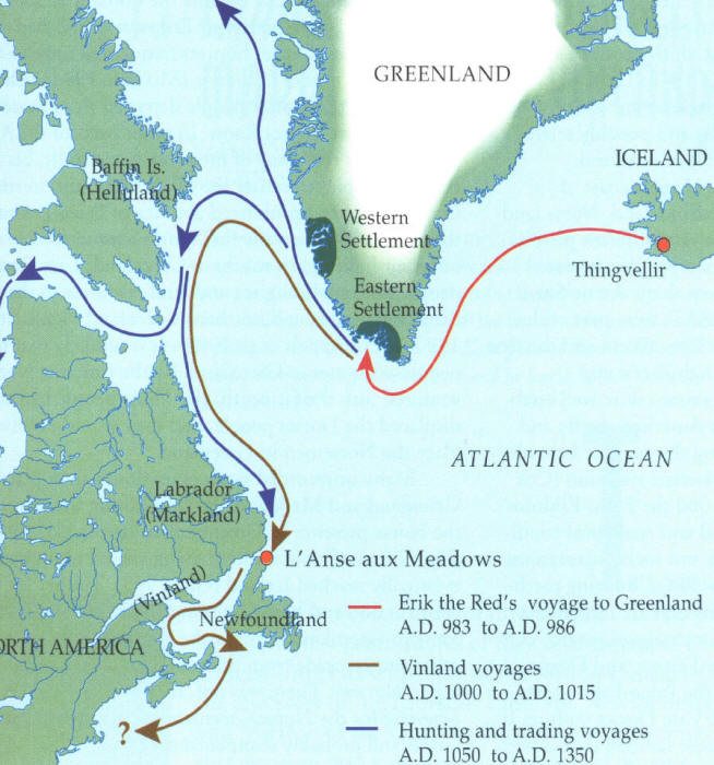 |
| Map showing possible Norse routes |
In the spring, Leif returned to Greenland carrying a cargo of grapes, grape vines, and timber. His brother as well as other Norse adventurers later explored the same areas, sometimes fighting and sometimes trading with the natives there. They used Gaelic runners to explore three days over land. The runners returned with more grapes and wheat. There are at least two other historical references to Vinland , aside from semi-legendary Norse Sagas. One source even predates at least the writing of the Norse Sagas.
There have been many theories presented which seek to match Vinland with a modern location. In 1960, a Norse settlement was discovered on the northern tip of Newfoundland Newfoundland
As I said, there are probably hundreds of artifacts and unexplained pre-Columbian sites which claim Norse origins. I have plans to visit several of them as seasonal museums begin to open. However, Follins Pond, in the towns of Dennis and Yarmouth Vinland .
Most of the evidence supporting a Norse visit to Follins Pond can be attributed to research conducted by the former writer, teacher, and amateur archeologist Frederick J. Pohl. Pohl believed that Leif Ericson entered the mouth of Bass River in Cape Cod , traveled several miles up the river, and ultimately camped on the shores of Follins. Certainly the area is reminiscent of the description of Vinland in the Norse Sagas.
In 1952, the Massachusetts Archeological Society (MAS) conducted digs in the areas of Follins Pond most suspected of Norse visitation. In the January 1953 Bulletin of the Massachusetts Archeological Society, Benjamin L. Smith, outlined the work conducted by the MAS in an article entitled A Report on the Follins Pond Investigation.
According to Smith, several interesting things were discovered during the dig which some believed were suggestive of a Norse presence. The first piece of controversial evidence included several buried wooden posts and stones, potentially used to support a shored ship. In addition, the wood seemed to have been shaped by a metal axe. Yet, members of the Archeological Society estimated that the wood and construction was no more than 90 – 150 years old because the wood was not completely rotted. They theorized that the ship might have been a colonial ship hidden from the British during the War of 1812 or the Revolutionary War. In addition, they were informed by local historians that the area in which the posts were discovered was once used by Cape fisherman as a boat landing.
However, in the 1955 article entitled Comments on the Follins Pond Report, Pohl expressed his disagreement with the findings of the MAS. He stated that the shape, size, and estimated weight of the construction of wooden posts and stones suggested the shape of a classic Norse ship. He also suggested that the wood might have been well preserved by having been buried several feet under the shore bank immersed in an oxygen deprived environment. Therefore, the wood might be centuries older than it appeared.
 |
| Map of the Follins Pond digs- MAS |
In addition, another piece of evidence Frederick Pohl suggested as proof of a Norse visitation to Cape Cod were the existence of what he called “Mooring Holes” in several rocks along the shore of the Follins Pond and Bass River. According to Pohl, these holes were drilled manually into rocks always at a slight angle. In these rocks would be placed a large iron pin with an eye-hole, which attached the ship to shore by use of ropes. These were of particular interest to Pohl because similar holes have been discovered in more classically Norse areas like the fjords of Scandinavia .
Furthermore, some of these holes seemingly presented with specific characteristics which the “mooring holes” of Norse Europe would have displayed. For instance, some of the holes on Cape Cod were slightly triangular in shape, with bulging, rounded sides. To Pohl this indicated that they were chiseled by hand, rather than drilled mechanically.
However, the MAS also responded to this evidence in their original report. Smith suggested that most of the holes were drilled for the purpose of blasting the nearby rocks with explosives. The rocks were then used to create the breakwater at the mouth of Bass River Cape also left triangular shaped holes with wide bulging sides. Therefore, even if the holes were mooring holes, there was no way to tell when they were created.
 |
| Large rocks along Follins Pond |
In his 1953 article, Frederick Pohl defended his theory concerning the mooring holes. He conceded that he may not know exactly when the mooring holes were bored into the rocks along Follins Pond, but was sure that they were not holes intended for blasting rock used in the construction of the Bass River Breakwater. He stated that such holes would have been larger, more circular, and there would have needed to be several holes per large rock.
However, the existence of odd holes and the remnants of a shored boat were not the only pieces of evidence discovered to support Ericson’s visit to the Cape . In an article entitled An Osseous Find at Follins Pond, an archeologist named Bernard W. Powell reported his findings after having examined a domestic horse bone found near Follins. The bone was discovered by a local home owner. Powell explained that the remains of domestic horses are present in the Greenland settlements, though rare. Hence, it would be plausible that the Norse who might have explored the Cape might also have been in the company of horses. Unfortunately Powell could not determine the age of the bone. He suggested that the potential weight of the animal belonging to the bone might be of a weight comparative to Norse domestic horses, but not much else could be determined. Hence, this piece of evidence, like the mooring holes and remains of the shored boat, are simply circumstantial.
In my short exploration of the Follins Pond area, my fiancé and I were able to see how the pond easily connects to Bass River , and from Bass River
 |
| Bass River from Bass River Bridge- May 2012 |
However, we were ultimately unable to get close to any large rocks along the shore which could have been examples of Pohl’s mooring stones. The shore of the pond is covered with private beaches and back yards of private properties. There are very few public access areas along the pond, and none have large stones near them that we could see. We could not get very close to the area called the “gully,” which is displayed on the map of Follins created by the MAS. This was the spot at which the remains of the ship was discovered. However, I was able to take several pictures of this area from across the pond at a public boat landing, but I would have liked to poke around there myself. Maybe I can return to this area with my kayak sometime this summer and attempt to locate some of the areas displayed on the map without having to trespass.
 |
| The Gully area from a distance Remains of a shored ship was unearthed here |
So it seems that the mystery of the modern location of Ericson’s Vinland remains unsolved. It might have been the small Norse settlement discovered in Newfoundland Cape Cod . Pohl certainly believed it was, even refusing to accept the conclusions of the MAS investigation.
However, after reviewing the evidence supporting Pohl’s Follins Pond theory, I have to admit that there is some evidence suggesting a thousand year old Norse visitation, but there is not enough to conclusively say Ericson and his explorers were ever here. This, however, does not seem to matter to the residents of Dennis and Yarmouth Saga Road , Vinland Drive , and Leif Ericson Drive .
Whether or not any evidence will ever prove the Cape’s association with Ericson’s Vinland is pretty dubious. Archeologist, Bernard Powell, thoroughly explained why it is so difficult to locate proof of a small thousand year old Norse settlement (as if an explanation was needed). In his article The Mooring Hole Problem in Long Island Sound, Powell discusses the research conducted by Pohl. He mentions that Native Americans have lived in the Northeast in substantial numbers for thousands of years and very often archeologists come up with no proof of their habitation in places where researchers know they lived and worked. Imagine then, attempting to find the camps of only about 300 Norseman who might have journeyed to Vinland a thousand year ago for only one or two summers. Not only is it improbable, but it seems mindblowingly impossible to be able to locate absolute proof.
Still, as I mentioned, there are several Norse related curiosities throughout New England , other than the evidence discovered at Follins Pond. These oddly built structures and puzzling artifacts like Dighton Rock, the Bourne Stone, and America ’s Stonehenge hint at the possibility of some unknown presence mingling with the Native tribes and cultures of ancient New England . However, I could not say if these were the works of Leif Ericson and his crew. Yet, certainly the possibility exists, and should not yet be dismissed, that a thousand years ago, dragon-prowed Viking longships once slipped from the primordial New England mists to leave their mark somewhere on our Yankee shores.

Tuesday, May 15, 2012
Historical Misconceptions
I am currently writing an article on the Norse discovery of the New World around 1000 AD. I came across this short video during my research which addresses 5 of the most common historical misconceptions. I thought it was hilarious, and it also includes the “Vikings.” Take a look in preparation for the next article or just for a laugh.
Tuesday, May 8, 2012
Roanoke Colony- New Clues
 |
| Governor White's map of the Roanoke Colony |
The creation and disappearance of the Roanoke Colony is a very interesting story, it was always one of my favorites to teach in American History.
The colony at which the settlers hoped to live had been previously established by the English and had been left with only a skeleton crew of soldiers to maintain it in anticipation of new arrivals and new supplies. However, when White and his group arrived there was no one left in the colony. Although odd, the previous occupants of the fort had run afoul with local native groups. The fort had been attacked by natives before and had also been completely abandoned at one time.
Although White and his colonists were depending on the men that remained, they stayed in an attempt to re-establish the fort and colony. John White became the Governor of Roanoke. He tried his best to create peaceful relationships with the tribes surrounding the colony, including the Croatans. During this time his daughter gave birth to the first English child thought to have been born in the
Despite Governor White’s efforts with the local tribes, one of the
Because of
White believed that the colonists had traveled to
There have obviously been several hundred theories presented since 1590, which attempt to explain the disappearance of the
Even the Jamestown Colonists, including the famous John Smith, was interested in finding the lost colonists. Although not necessarily a reliable source, he was told by Powhatan (the father of Pocahontas), that the colonists who had once been at
However, the evidence discovered recently does not seem to support any of the established theories. According to ABC news, a map created by Governor John White in 1585 indicates that the colonists might have moved west up the Albemarle Sound to the area where the Chowan and
This new evidence was discovered by examining two patches attached to Governor White’s map, which had apparently never been looked at before. One patch appeared to be a simple correction to the original, but the other hid a small symbol representing the existence of a second English fort. Scholars believe the symbol of the fort could indicate where White believed the colonists could have gone. The article reports that this discovery would not have been made had one of the researchers not recently pondered what might be hidden under the two patches.
Although the discovery on White’s map is fascinating, the area it indicates is now privately owned. Some of it even appears to be covered by a golf course, so archeological digs will have to wait several years, if they happen at all.
This type of discovery is interesting. The fate of the
This is certainly also an interesting lesson in historical research for everyone. No matter how many times one has examined a single source, looking at it carefully and objectively one more time might reveal a hidden clue previously missed by hundreds of researchers who believed they knew everything about the source in front of them. There are literally thousands of unsolved historical mysteries; some are probably in walking distance from your own home. In addition, in our digital age, one no longer necessarily has to sift through dusty old pages in dank dark archives (though that can be fun too). So start digging people. You never know if you will be the researcher that asks that one simple question that cracks a case hundreds of years old or as new as yesterday.
Subscribe to:
Posts (Atom)