Showing posts with label History's Mysteries. Show all posts

Wednesday, July 3, 2013

The Mystery of Cape Cod's Boundary Stones

I was very busy this spring preparing an article for the June 2013 Summerscape, which is published by the Barnstable Patriot. My article article is now available online. I very much enjoyed participating in Summerscape this year and thank the editors for allowing me to do so. The subject of my research concerned the creation of the original town boundaries on Cape Cod, or at least one of the theories that tries to explain the boundaries. The research was absolutely fascinating and took me to places and sources I had never seen before. Through these sources it became clear to me that there are still so many things we do not know about the history of the Cape, how our town earned their borders is just one of them.

One of the biggest mysteries uncovered in my research has been the lack of information surrounding the various boundary stones one can find sitting on Cape town lines. Although a couple of these markers are registered as important landmarks by the National Register of Historic Places, there is still very little information explaining where they even came from, when they were placed at their current locations, and who placed them there.

In my article for Summerscape, I focused primarily on the stone uncovered by Michael Faber’s Cornerstone Project. This large flat boulder is located just off Rt. 6a, between Barnstable and Yarmouth. It very clearly has the letters "YxB" chiseled into its surface, signifying the boundary between the towns. However, as to who did the chiseling and when it was done . . . no one seems to know. The earliest concrete historical reference to the existence of the stone can be found in a 1907 Atlas. Although its existence in 1907 makes the stone historical at this point in time, there are some who believe it was created as part of the originally boundary between Yarmouth and Barnstable. This would date the inscription to around 1641.

The YxB Stone - Spring 2013
As the Summerscape article focuses heavily on the history of the “YxB” stone and the theories of the Cornerstone Project, I won’t restate huge portions of it here. If you’d like to know more about the stone, do check out the Summerscape link. Instead, I wanted to expand upon some of the other sources I didn’t use previously.

The other set of markers I researched, but did not devote as much space to in the article, were the boundary stones between the towns of Sandwich and Barnstable. One of these, a marker along Race Lane in Sandwich, has been recognized by the National Register of Historic Places since about 1987. This marker is a simple stone post a little over 2 feet tall. The letters "B/S" have been carved on its surface, showing the boundary between Barnstable and Sandwich.
Marker on Race Ln - you can just see the B/S at the bottom
According to their information, this marker was erected in 1639 when Myles Standish and John Alden were sent by the Plymouth Court to settle the boundaries of Sandwich. Of course, no one can prove this to be true. Even the records of the Plymouth Court are unclear about when the boundary between these two towns was officially established.

Plymouth Court records indicate that Standish and Alden were tasked as early as 1638 with the establishment of the Sandwich boundaries. However, the same records show that boundary disputes between Sandwich and Barnstable needed reconciling in both 1651 and 1652. However, it was not until June of 1670 that bounds were actually set in writing by the court. Though the Plymouth records make no mention of the creation of a stone marker, this particular boundary stone was referenced in a 1901 report on bounds of Sandwich, which is now housed in the Sandwich archives. Again, no mention of who created it or when it was put there.

Although some may argue that just because no one knows the exact origins of these boundary stones and their carvings, it doesn’t make them really mysterious. Cape Codders pass by them every day and they are as common as spring weeds on the side of our roads. Our forefathers just did not think to record exactly when they were placed, which is a shame because history geeks like me would like to know.

Still, the marker stones are part of a greater Cape Cod unknown. Truthfully, we only have bits and pieces of sources that explain the creation of the boundaries between the modern Cape towns. As I explain in the article, the Cornerstone Project has been trying to prove one theory; that these boundaries were surveyed and marked from a ship in Cape Cod Bay. While it is an interesting theory, I am still left without any rock solid historic facts as proof. Until then, as with other posts on this blog, the mystery persists.

Friday, December 7, 2012

Roger Williams' Code Cracked


Roger Williams
According to the Washington Post, as well as many other sources, a long enduring mystery concerning Rhode Island’s founding father has recently been solved. Roger Williams was not only the founder of the Providence Plantation, he was one of the first men to preach for a separation of Church and State. In addiiton to leaving behind a tradition of religious dissent, he also left us pages worth of code in his own hand.

Williams has long been imfamous and famous for his conflict with the government of Massachusetts. Soon after his arrival in Boston, Williams made his religious views clear. He stated that people should be free to follow their own conscience in religious matters, because he believed the conscience was a gift from God. In addition, while in Plymouth, he openly questioned the practice of illegally acquiring land from the local Wampanoags. For these views, he was banished from Massachusetts in 1635.

Williams spent the next several months as a guest of Massasoit, only to further flee the influence of Massachusetts by entering the territory of the Narragansett tribe in modern day Rhode Island. It was in Rhode Island where Williams and a group of his closest followers purchased land from the Sachem of the Narragansett to create their own plantation. He called the area Providence, because he felt that it was God’s providence which led him there. From its birth, Providence became a haven for those who were deemed religious dissenters.

Although most of the life of Roger Williams is well documented, he left behind a mystery. In a 250 page volume entitled “An Essay Towards the Reconciling of Differences Among Christians,” William left pages of written code. Although the book was donated to the Brown University Library in the 1800’s, the code within had never been deciphered.
Preface of the Mysery Book at the Brown University Library
Provided by Brown University
Although attempts had been made at a translation in the past by university staff, this year Brown University extended the challenge of the mysterious code to undergraduate students. Several students accepted the challenge and began independent research projects.

Finally, a 21 year old senior at Brown began to make some progress. Lucas Mason-Brown, who majors in math, first attempted to solve the code by analyzing the frequency of the different symbols and how often they appear in groups together. This did not initially prove helpful.

Mason-Brown then studied Roger Williams. He learned that Williams had been trained in shorthand while living in London. Using these clues, he was able to create a key to Williams’ code. He found that the code used 28 symbols which stood for either English letters or sounds. These symbols could then be arranged and re-arranged to make words. Mason-Brown also found that Williams often improvised his code, which sometimes made translation difficult.

The translation provided three separate sections of Roger Williams’ own notes and thoughts. Unsurprisingly, the content of many of these notes dealt with religious issues of the day, like infant baptism. In addition, Williams commented on the conversion of Native tribes to Christianity, which he felt was being done deceptively. These new translations give huge insight into the mind of Roger Williams toward the end of his life. It will certainly be fascinating to see what Williams was secretly writing about in the margins of his books, as he was already so vocal about his controversial opinions.

I find this type of discovery both interesting and instructive. I have often heard the theory that an historic education has very little practical application in life. In some ways, I agree. I could possibly live my life without my love of history. But I guess I could live a dull life without color, or candy, or bacon cheeseburgers too. I wouldn’t want to, mind you.  However, in the case of cracking the Roger Williams code, a student first attempted to use a math based solution, which failed. Ultimately, it was through historic study and a knowledge of the life of Williams that a key to the mystery was found. There are literally thousands of modern mysteries waiting to be solved. One should never rule out the possibility that the solution to any of them might actually be found in the past.

Wednesday, October 31, 2012

The Bourne Stone - Bourne, Ma


The Bourne Stone - Summer 2012
I first became interested in the Bourne Stone years ago, when I learned that no one really knew who made it or what its writing meant. It was one of the first real unsolved New England mysteries that caught my attention. This was before I realized there were literally thousands of unsolved New England mysteries. Still, the Bourne Stone is unique, if not frustrating. As I learned when I began researching the stone’s history, everyone seems to find a place for the Bourne Stone to fit within their particular view of the discovery and colonization of the New World. What is left are a lot of theories, but very few verifiable facts.

What researchers really know about the stone is very basic and does not extend too far into the historic record. The stone, which currently resides at the Jonathan Bourne Historical Society, is a 300 pound block of granite. What makes this block stand out from others are the strange characters carved into it. According to the Bourne Historical Society, the stone was originally used as a doorstep to one of the Indian Meetinghouses established by Thomas Tupper, an early resident and missionary of Sandwich.

It was originally difficult to nail down exactly which Indian Meetinghouse the stone was supposedly first placed at, as references to it do not often appear in historic writing. In addition, according to information provided by the Massachusetts Historical Commission, there were several Indian meetinghouses erected in Bourne. The first church created for the natives was established in 1675 by Thomas Tupper and Richard Bourne near Burrying Hill in Bournedale. A plaque was created to commemorate the area where this initial church stood. The wife and I saw this plaque when investigating Chamber Rock. This building, however, did not apparently contain the Bourne Stone.

The plaque at Burying Hill

The second Indian Meetinghouse was built in 1688 by a carpenter named Edward Milton. The construction of the meetinghouse was funded by Judge Samuel Sewall, who would later become infamous for his involvement in the Salem Witch Trials between 1692 and 1693.

According to Sewall’s Letter-Book, Judge Sewall had appointed Thomas Tupper to oversee the construction of this meetinghouse a year earlier. Sewall’s letters certainly describe how the meetinghouse was built, but definitely make no reference to the presence of a mysterious stone being added to the doorstep of the church building. Still, it was at this location, according to RA Lovell in Sandwich: A Cape Cod Town, where the Bourne Stone was eventually found. This second meetinghouse was located near a traditional Wampanoag cemetery, on the southern edge of Great Herring Pond. The cemetery in Bourndale was easy enough to find and visit, however I could not see any trace of the foundation of the second meetinghouse.

Map showing Indian Meetinghouse - Sandwich: a Cape Cod Town

Old Indian Burial Ground- Bourndale 2012
The Second Meetinghouse was built near this cemetery


I can’t seem to find any written native or colonial reactions to the stone or its writing. However, popular folklore indicates that the writing on the Bourne Stone was initially placed face down to prevent the local natives from panicking when they saw it. Though I can’t source this information, I still found the story interesting. However, just as many sources seem to indicate that the writing on the stone only appeared after its use as a doorstep.

As to the fate of the Second Indian Meetinghouse, Lovell relates the local folklore, which states that it was eventually infested with blacksnakes (somewhat disgusting). The building was moved to the eastern shore of the Great Herring Pond. After the removal of the church, the stone seems to have been moved a short distance to the residence of a Herring Pond Wampanoag named Andrew Jackson. However, some sources state this home was built on the foundation of the meetinghouse. Regardless, this home burned down in 1932. When the property was sold to someone outside the family and tribe, the stone was donated to the newly created Aptuxet Trading Post Museum for future preservation and study. By this time, the writing on the face of the giant block was well known, but all memory or record of its original purpose upon creation had been lost. As of now, it can be viewed at the Jonathan Bourne Historical Center.

Certainly, since its removal to the museum, people have wondered and guessed at the meaning of the writing covering the surface of the stone. Some have claimed the writing was of native origin, many thought it was left by Norse explorers, some have claimed it was Celtic, and still others have gone to great pains to prove that the writing was left by Carthaginian explorers to New England.

Perhaps the most accepted and well recognized explanation for the Bourne Stone attributes the strange writing to the Norse explorers, including Leif Erikson, who might have reached as far south as Cape Cod in 1000 AD. According to the Cape Cod Times, Frederick Pohl and Norse runic expert Olaf Strandwold examined the stone’s writing. Strandwold believed the markings were in fact runic and could be translated as, "Jesus amply provides for us here in Heaven." Pohl, however, also admitted that translations may vary.

Although the Norse theory is perhaps the most well spread, when researching the Bourne Stone, two names and two additional theories continued to pop up again and again. In fact, when looking into the Bourne Stone, it would seem impossible not to encounter the theories and writing of Edmund B. Delabarre and Barry Fells. Both men investigated the writing on the stone and believed they had conclusively teased out their origins, though neither of them believed the Norse created the writing.

Chronologically, Delabarre began researching the Bourne Stone first. Edmund Delabarre was a professor of psychology from Brown University. He focused on the fields of shape perception and the mental processes related to involuntary movements. Although neither a historian nor an archeologist, Delabarre intensely studied both Dighton Rock and the Bourne Stone. He presented most of his theories concerning these two New England curiosities between 1919 and 1940.

Edmund B. Delabarre

Delabarre outlined his theories in at least two articles. One, he wrote for Old Time New England magazine, entitled The Indian Petroglyph at the Aptuxet Trading Post in Bourne, Massachusetts. The second article he wrote for the Rhode Island Historical Commission, it is titled Miguel Corte-Real: The First European to Enter the Narragansett Bay. Both pieces were written in 1936, very soon after the Bourne Stone was donated to the Aptuxet Museum.

As the title of one of Delabarre’s papers suggests, he believed that the Portuguese explorer Miguel Corte-Real accidently began exploring New England between 1502 and 1511. Most historians agree that Corte-Real had been on mission to find his brother Gasper, who had never returned from a previous expedition to the New World. Like his brother Gasper, Miguel was never heard from again. Most believe he and his crew were lost somewhere in the Atlantic Ocean or along the coast of Newfoundland.

However, Delabarre theorized that Corte-Real entered the Narragansett Bay after sailing south in search of his brother. From there he entered the Taunton River and finally ended his voyage (perhaps shipwrecked) at Assonet Neck in Freetown, Massachusetts. Delabarre believed that Dighton Rock, which once sat beside the Taunton River, bears the name of Corte-Real as evidence of his presence in New England. Not only did the Portuguese explorer carved his name into Dighton Rock, but Delabarre insisted Corte-Real also included the year 1511, the coat-of-arms of the Portuguese king, and a message in Latin which explained that he had become king or Sachem of the local natives.

Dighton Rock

Delabarre further explained that the Portuguese sailors with Corte-Real may have intermarried and fathered children with women of the Wampanoags. He used the writings of the Italian explorer Giovanni Da Verrazzano as further evidence to support his case. According to Verrazzano’s Voyage Along the Atlantic Coast of North America, 1524, Verrazzano explored the Narragansett Bay in 1524, eventually encountering the Rhode Island Wampanoags several years after Corte-Real's theoretical landing. Verrazzano wrote:
"This is the most beautiful people and the most civilized in customs that we have found in this navigation. They excel us in size; they are of bronze color, some inclining more toward whiteness, others to tawny color; the face sharply cut, the hair long and black, upon which they bestow the greatest study in adorning it; the eyes black and alert, the bearing kind and gentle."
Hence, Delabarre believed that Verrazzano had encountered the descendants of Corte-Real’s crew. He made the case that the inclusion of Portuguese DNA might have created this inclination toward lighter skin and also a resistance toward European diseases as well. In fact Delabarre poses that the name Wampanoag might have actually meant "White People," rather than "Eastern People," as most believe it does today.

Furthermore, though most historians agree that the Wampanoags had no written language until very recently, Delabarre suggested that they were developing an ideographic written language at about the same time that Metacomet was Sachem (1662 – 1676). Delabarre used the Bourne Stone and other unexplained petroglyphs as evidence of this language. In examining the Bourne Stone, Delabarre first guessed that one of the symbols on the stone represented a white man and a native shaking hands (figures 1 and 2 in the below graphic). He compared the symbol to similar ones seen on William Penn’s Wampum belt (figure 8) and on Dighton Rock (figure 7).
From Miguel Corte-Real- Edmund Delabarre
Figures 1+2 from the Bourne Stone
Figure 7 from Dighton Rock
Figure 8 from Penn's wampum belt
Delabarre believed they are represented a native and a white man


Penn's actual wampum belt
Although Delabarre did not offer a full translation of the Bourne Stone, he believed he had found meanings for several symbols included on Dighton Rock, the Bourne Stone, and a third Bannserstone found in Warren, Ma. According to the above graphic he created for the Rhode Island Historical Commission, symbol 3 represents a Sachem, symbol 4 represents the idea of "white," symbol 5 represents a people or a tribe, and symbol 6 represents Metacomet or King Philip, as Delabarre believed it closely resembled Metacomet's own signature.

Of course, these symbols do not all appear on the Bourne Stone and do not offer a means of understanding what might be written there. In addition, the legends of lost European tribes in the New World are numerous and often nothing more than myth. Futhermore, in 1971, Samuel Elliot Morrison dismissed Delabbare’s evidence in his book The European Discovery of America: The Northern Voyages. Still, Delabarre’s ideas offered some of the first explanations for the mysterious writing present on the Bourne Stone. However, his theory is definitely not the only one.

In 1976, a marine biologist employed by Harvard University began making waves in the world of accepted history and archaeology by claiming in his book America B.C. that Europeans, Carthaginians, and Phoenicians had made pre-Columbian contact with the New World. The Bourne Stone was among the many sites and curiosities which Fell examined. In addition, Fell believed he could offer a full translation of the stone's script.
Howard Barraclough "Barry" Fell
According to a 1975 article in the Springfield Union, Fell was invited to examine the Bourne Stone by James Whittail of the Early Sites Research Society. Fell worked all night in an attempt to translate the writing on the stone, and by morning offered a solution to the mystery of the stone's writing.

Fell explained that the writing on the Bourne Stone was an example of a variation in the Punic alphabet of Carthage which Fell claimed was used in the ancient Iberian Peninsula. Fell coined the term "Iberic" for the script. According to Fell the inscription on the face of the Bourne Stone reads, "Proclamation of annexation. Do not deface. By this Hanno takes possession."
An example of Punic writing for comparison
Fell believed the Hanno to which the stone referred was the Carthaginian King Hanno the Navigator, who was sent by the city of Carthage around 500 BC to explore the northwestern coast of Africa.

The only account of Hanno’s exploration comes from a Greek translation of a tablet Hanno deposited in the temple of Ba’al upon his return to Carthage. The tablet is known by the overly full title of The Voyage of Hanno, commander of the Carthaginians, round the parts of Libya beyond the Pillars of Heracles, which he deposited in the Temple of Kronos. The Greeks equated the Carthaginian Ba’al with their god Kronos.

Of course, the Greek translation did not provide any insight into Hanno’s visit to the New World. However, Fell believed that Hanno made a second voyage to the New World for which the Greek record, if it ever existed, was lost. In addition to the Bourne Stone, Fell believed the Carthaginians left their Iberic script in several other places in New England, including Mystery Hill in New Hampshire, and Dighton Rock.

However, few professional academics agreed with Fell’s description of the Bourne Stone. Anthropologists and archaeologists accused Fell of being amateurish and unconvincing. Some have even concluded that his later work relating to the Celtic language Ogham might have been outright fraud. However, others have recognized that Fell’s contributions to archaeology and linguistics might have at least brought needed attention to some of the unexplained curiosities which might suggest pre-Columbian European contact with the New World.

Furthermore, the Bourne Stone was most recently studied in 2004. In Collaboration In Archaeological Practice: Engaging Descendant Communities, Larry J. Zimmerman explained his own theory concerning the Bourne Stone. Zimmerman invited Norse runic expert Michael Barnes to examine the stone’s writing. According to Zimmerman, Barnes believed the writing was definitely not runic. This, of course, contradicted the previous theory of Olaf Strandwold. In addition, Zimmerman and archaeologist Patricia Emerson believed that the writing looked more like Native American petroglyphs or even natural markings. Although, they did not offer an explanation for what message the Bourne Stone was meant to convey. Neither did they support the theories of Fell or Delabarre.

After examining the available research related to the Bourne Stone, I have gained a greater appreciation for the potential for new discoveries related to pre-Columbian New England. Of course, I still do not know for certain what the writing on its face actually says, if it says anything at all. I don’t know that further study would give us the answer either, as everyone tends to interpret the characters so differently. Again, sometimes history is hard.

However, as most of the theorists have guessed, I would also pose that the writing on the Bourne Stone is connected to other unexplained New England sites like Mystery Hill and Dighton Rock. In addition, although I am uncertain if an ancient Carthaginian visited our neck of the woods, I do believe that we are just beginning to tease out the lines between legend and reality when it comes to the history of New England before the arrival of fifteenth century Europeans. As we begin to learn more, and as technology begins to fill in where traditional history and archaeology leave gaps, I think what we uncover will astound us and completely rewrite what we know about the people and the supposed discovery of North and South America.

Sunday, September 30, 2012

Bourne Stone Preview

I have been very busy helping to plan my wedding, which is in 13 days! The Fiancé and I are very excited. We’re putting table plans together, taking dance lessons (mostly because I am a hopeless dancer), and taking care of all those last minute details and problems that come up before all weddings.

This has not left me a lot of time to research. However, I have been slowly putting together my notes on the Bourne Stone, which will be ready for an early October posting. Until then, CapeCast did a very interesting video on the mystery of the Bourne Stone, which summarizes many of the things I have been learning about it. Check out the video and look for a future post next month.

Wednesday, August 29, 2012

Jonathan Bourne Historical Center- Bourne, Ma

Jonathan Bourne Histrical Center Summer 2012
I recently had the time and opportunity to visit the Jonathan Bourne Historical Center in Bourne, Ma. Visiting the Historical Center allowed me to see a few of their exhibits which I have been meaning to check out for a long time. It also allowed me to see a few I had not known about. Of course these have now peaked my interest and propelled me into future research projects.

The Jonathan Bourne Historical Center is located on 30 Keene Street, in Bourne Ma. The Center itself was built in 1897 by Emily Howland Bourne, who is a descendant of the prolific and regionally important Richard Bourne.

I have written about Richard Bourne several times now, as he was one of the first Christian missionaries to the local Wampanoag tribe and is also connected to the Wampanoag Indian Museum through one of his descendants.

The Historical Center building originally served as a town library. Emily Bourne had the library built in honor of her father, Jonathan Bourne. Jonathan, though a prominent resident of New Bedford at the time, was instrumental in helping the residents of Bourne achieve separation from the town of Sandwich in 1884. Because of his assistance, the new town was named after Jonathan Bourne and the Bourne family.

Bust of Jonathan Bourne at the Historical Center
The building houses the Bourne Historical Society, the Bourne Historical Commission, and the Bourne Archives. Not only does the Historical Center advise the town of Bourne on issues of historical preservation, but it also contains town records like historical maps, photos, family records, oral histories, and historic books through the inclusion of the archives. This makes the center a valuable historic resource in its own right.

The building also houses many interesting exhibits. Among the most famous is the mysterious Bourne Stone, which I will be researching for a post in the very near future. However, their largest and most current exhibit is a display containing posters and artifacts from both the First and Second World Wars.

WWI and WWII Posters and Artifacts
This exhibit not only contains several interesting propaganda posters from the allied persepctive, but also contains a display which details information on the military career of Sergeant Stubby, the most decorated war dog of World War I. Although he appears to be an early Boston Terrier type, his true breed appears to have been unknown. However, he did originate in Connecticut, which makes him a Yankee, and worthy of a more detailed post in the near future.


Stubby the War Dog
An additional exhibit which caught my attention was on one of the few serial killers to grace the shores of Cape Cod. Nicknamed Jolly Jane, she was reportedly responsible for the deaths of nearly every member of an entire family.
Jolly Jane's Exhibit
While visiting the Historic Center, I drove a couple miles down the road to check out the recreation of the Aptuxet Trading Post. The building sits on the foundation of what is thought to be the original 1627 trading post, which once sat alongside the Manamet River. The original course of the river was incorporated into the digging of the Cape Cod Canal. The current museum is a recreation of what the post was thought to have looked like.
Aptuxet Trading Post Museum
The Jonathan Bourne Historical Center is open Mondays and Tuesdays 9am to 2:30pm. It is also open the second and fourth Wednesday of the month from 6:30pm to 8:30pm.

I had a great time visiting the Bourne Historical Center and the Aptuxet Trading Pos Museum.. Not only did I once again visit a museum dedicated to local history, but I learned several new things and was inspired to continue learning about what I saw. To me, that’s what its all about. As I’ve said, during the next few weeks, I hope to continue researching the Bourne Stone, Jolly Jane, and Stubby the war dog in order to create detailed posts about each.

Until then, if you are in the area, take time to visit the Jonathon Bourne Historical Center for yourself. It’s a great opportunity to admire objects and exhibits dedicated to some of the odder, more mysterious, and less well known subjects within New England History. In addition, it is a great example of how important smaller local museums are to the continued effort to preserve an archive our Yankee heritage for posterity.

Thursday, May 31, 2012

Blue Rock of Bass River

I’m a little disappointed that I did not find this awesome Cape Cast video until after I finished researching Follins Pond and Leif Ericson. I know this area well and I could have found the Blue Rock, which seems to have an example of what was considered by some to be a mooring hole. However, this video also expresses doubt that these holes were created by Norseman. When I get my kayak up in this area in the near future, I will get my own photos of Bass River’s Blue Rock. Until then, enjoy the video.

Thursday, May 24, 2012

Leif Ericson and Follins Pond- Yamouth, Ma

Dragon-prowed Norse Longship
Throughout New England there are many sites and archeological finds which seem to suggest that Norse dragon ships, along with their European passengers, may have arrived in the North East of the United States about 500 years before Columbus accidentally landed in the Caribbean. Though, the majority of these finds remain categorized as mere curiosities, there are several that suggest history books concerning the subject of the discovery of the New World should be re-written.

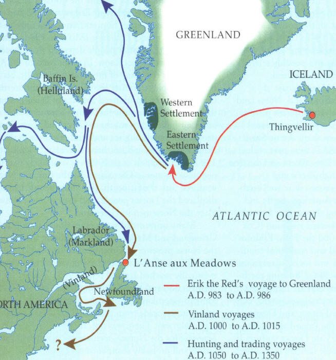
Information of possible Norse exploration comes from very few historical sources. In fact, the majority of the information comes from the Norse Sagas, including The Saga of Eric the Red and The Saga of the Greenlanders. Although the sagas depict events that took place around 1000 AD, they were not committed to writing until the 13th century. According to the sagas, the story begins with Eric the Red, an Icelander who was banished from Iceland for manslaughter around 982 AD. During his banishment, Eric explored and settled Greenland.

Eric the Red
 The Sagas give two versions of how land was discovered west of Greenland. In one version, it seems that the son of Eric the Red, known as Leif Ericson, first sighted new land while sailing to Iceland in order to spread Christianity. However, the second version states that in 985, a Norseman named Bjarni was sailing from Iceland to Greenland. He was blown off course, only to find himself near the coast of an unknown land. After skirting the shores of several strange areas, Bjarni eventually arrived safely in Greenland at this father’s settlement. According to the Saga of the Greenlanders, he never sailed again. However, he did report what he had seen to Leif Ericson.
Leif Ericson by Christian King
The tale goes on to say that Leif purchased Bjarni’s ship and gathered adventurers to sail west in an attempt to locate this new land. Eric the Red was about to join his son on the expedition when he apparently fell off his horse, injuring himself. He saw this as a bad omen and declined to join Leif and his crew.

Leif followed Bjarni’s directions west and first landed on a flat rocky shore, he called Helluland, which means appropriately “Land of Flat Stones.” Most researchers agree that this was most likely Baffin Island, which is the largest island in Canada. Though, some also suggest that it might have been north Labrador. Though Ericson interacted with the natives on the island, whom the Norse called skraelings, he ultimately decided not to settle in Helluland because it was inhospitable.

Traveling further, Erikson and his crew landed in a forested area which he called Markland. In Old Norse, the name means “Forestland.” Again, there is agreement that this was probably Labrador. Later the Greenlanders used this area to gather timber.

Leif Ericson continued to sail south for two more days. He next arrived at a place he called Vinland, which is generally translated as “Wine Land” or “Meadow Land.” Here the Saga of the Greenlanders describes how Ericson sailed west past a Cape and entered a large river, which connected to a lake. The saga further states that this land was warm enough to allow their cattle to graze outside throughout the winter months. Ultimately, Leif Ericson decided to spend the winter in Vinland. He created a small settlement called Leifsbudir.
Map showing possible Norse routes
In the spring, Leif returned to Greenland carrying a cargo of grapes, grape vines, and timber. His brother as well as other Norse adventurers later explored the same areas, sometimes fighting and sometimes trading with the natives there. They used Gaelic runners to explore three days over land. The runners returned with more grapes and wheat. There are at least two other historical references to Vinland, aside from semi-legendary Norse Sagas. One source even predates at least the writing of the Norse Sagas.

There have been many theories presented which seek to match Vinland with a modern location. In 1960, a Norse settlement was discovered on the northern tip of Newfoundland. Many believe that this area, called L’Anse aux Meadows, is probably Leif Erikson’s camp. However, it has also been theorized that Vinland may have been a very large area, including at least three small settlements, the Newfoundland site being one of them.

As I said, there are probably hundreds of artifacts and unexplained pre-Columbian sites which claim Norse origins. I have plans to visit several of them as seasonal museums begin to open. However, Follins Pond, in the towns of Dennis and Yarmouth, is somewhat unique among these sites. Unlike many artifacts and areas people claim a Norse connection to, the Follins pond area has been at least researched by professional archeologists and historians. Some of these researchers even came to the conclusion that the shore Follins Pond was actually Leif Ericson’s camp in Vinland.

Most of the evidence supporting a Norse visit to Follins Pond can be attributed to research conducted by the former writer, teacher, and amateur archeologist Frederick J. Pohl. Pohl believed that Leif Ericson entered the mouth of Bass River in Cape Cod, traveled several miles up the river, and ultimately camped on the shores of Follins. Certainly the area is reminiscent of the description of Vinland in the Norse Sagas.

 In 1952, the Massachusetts Archeological Society (MAS) conducted digs in the areas of Follins Pond most suspected of Norse visitation. In the January 1953 Bulletin of the Massachusetts Archeological Society, Benjamin L. Smith, outlined the work conducted by the MAS in an article entitled A Report on the Follins Pond Investigation.

According to Smith, several interesting things were discovered during the dig which some believed were suggestive of a Norse presence. The first piece of controversial evidence included several buried wooden posts and stones, potentially used to support a shored ship. In addition, the wood seemed to have been shaped by a metal axe. Yet, members of the Archeological Society estimated that the wood and construction was no more than 90 – 150 years old because the wood was not completely rotted. They theorized that the ship might have been a colonial ship hidden from the British during the War of 1812 or the Revolutionary War. In addition, they were informed by local historians that the area in which the posts were discovered was once used by Cape fisherman as a boat landing.

However, in the 1955 article entitled Comments on the Follins Pond Report, Pohl expressed his disagreement with the findings of the MAS. He stated that the shape, size, and estimated weight of the construction of wooden posts and stones suggested the shape of a classic Norse ship. He also suggested that the wood might have been well preserved by having been buried several feet under the shore bank immersed in an oxygen deprived environment. Therefore, the wood might be centuries older than it appeared.

Map of the Follins Pond digs- MAS


In addition, another piece of evidence Frederick Pohl suggested as proof of a Norse visitation to Cape Cod were the existence of what he called “Mooring Holes” in several rocks along the shore of the Follins Pond and Bass River. According to Pohl, these holes were drilled manually into rocks always at a slight angle. In these rocks would be placed a large iron pin with an eye-hole, which attached the ship to shore by use of ropes. These were of particular interest to Pohl because similar holes have been discovered in more classically Norse areas like the fjords of Scandinavia.

Furthermore, some of these holes seemingly presented with specific characteristics which the “mooring holes” of Norse Europe would have displayed. For instance, some of the holes on Cape Cod were slightly triangular in shape, with bulging, rounded sides. To Pohl this indicated that they were chiseled by hand, rather than drilled mechanically.

However, the MAS also responded to this evidence in their original report. Smith suggested that most of the holes were drilled for the purpose of blasting the nearby rocks with explosives. The rocks were then used to create the breakwater at the mouth of Bass River. Furthermore, researchers from the MAS found that a type of drill widely used in the 19th century Cape also left triangular shaped holes with wide bulging sides. Therefore, even if the holes were mooring holes, there was no way to tell when they were created.

Large rocks along Follins Pond

In his 1953 article, Frederick Pohl defended his theory concerning the mooring holes. He conceded that he may not know exactly when the mooring holes were bored into the rocks along Follins Pond, but was sure that they were not holes intended for blasting rock used in the construction of the Bass River Breakwater. He stated that such holes would have been larger, more circular, and there would have needed to be several holes per large rock.  

However, the existence of odd holes and the remnants of a shored boat were not the only pieces of evidence discovered to support Ericson’s visit to the Cape. In an article entitled An Osseous Find at Follins Pond, an archeologist named Bernard W. Powell reported his findings after having examined a domestic horse bone found near Follins. The bone was discovered by a local home owner. Powell explained that the remains of domestic horses are present in the Greenland settlements, though rare. Hence, it would be plausible that the Norse who might have explored the Cape might also have been in the company of horses. Unfortunately Powell could not determine the age of the bone. He suggested that the potential weight of the animal belonging to the bone might be of a weight comparative to Norse domestic horses, but not much else could be determined. Hence, this piece of evidence, like the mooring holes and remains of the shored boat, are simply circumstantial.

In my short exploration of the Follins Pond area, my fiancé and I were able to see how the pond easily connects to Bass River, and from Bass River to Nantucket Sound. Assuming it looked similar in 1000Ad, a 60 foot Viking ship could make the trip from the sound to the pond.
Bass River from Bass River Bridge- May 2012
However, we were ultimately unable to get close to any large rocks along the shore which could have been examples of Pohl’s mooring stones. The shore of the pond is covered with private beaches and back yards of private properties. There are very few public access areas along the pond, and none have large stones near them that we could see. We could not get very close to the area called the “gully,” which is displayed on the map of Follins created by the MAS. This was the spot at which the remains of the ship was discovered. However, I was able to take several pictures of this area from across the pond at a public boat landing, but I would have liked to poke around there myself. Maybe I can return to this area with my kayak sometime this summer and attempt to locate some of the areas displayed on the map without having to trespass.
The Gully area from a distance
Remains of a shored ship was unearthed here
So it seems that the mystery of the modern location of Ericson’s Vinland remains unsolved. It might have been the small Norse settlement discovered in Newfoundland, but it might yet be an area south of that. Its possible it could still be along the shores of Cape Cod. Pohl certainly believed it was, even refusing to accept the conclusions of the MAS investigation.

However, after reviewing the evidence supporting Pohl’s Follins Pond theory, I have to admit that there is some evidence suggesting a thousand year old Norse visitation, but there is not enough to conclusively say Ericson and his explorers were ever here. This, however, does not seem to matter to the residents of Dennis and Yarmouth. Many of the roads surrounding Follins Pond have classic Viking names like Norse Road, Saga Road, Vinland Drive, and Leif Ericson Drive.

Whether or not any evidence will ever prove the Cape’s association with Ericson’s Vinland is pretty dubious. Archeologist, Bernard Powell, thoroughly explained why it is so difficult to locate proof of a small thousand year old Norse settlement (as if an explanation was needed). In his article The Mooring Hole Problem in Long Island Sound, Powell discusses the research conducted by Pohl. He mentions that Native Americans have lived in the Northeast in substantial numbers for thousands of years and very often archeologists come up with no proof of their habitation in places where researchers know they lived and worked. Imagine then, attempting to find the camps of only about 300 Norseman who might have journeyed to Vinland a thousand year ago for only one or two summers. Not only is it improbable, but it seems mindblowingly impossible to be able to locate absolute proof.

Still, as I mentioned, there are several Norse related curiosities throughout New England, other than the evidence discovered at Follins Pond. These oddly built structures and puzzling artifacts like Dighton Rock, the Bourne Stone, and America’s Stonehenge hint at the possibility of some unknown presence mingling with the Native tribes and cultures of ancient New England. However, I could not say if these were the works of Leif Ericson and his crew. Yet, certainly the possibility exists, and should not yet be dismissed, that a thousand years ago, dragon-prowed Viking longships once slipped from the primordial New England mists to leave their mark somewhere on our Yankee shores.

Tuesday, May 8, 2012

Roanoke Colony- New Clues

Governor White's map of the Roanoke Colony
Although definitely not part of New England, I could not help jumping at the opportunity to write about a potential new clue discovered about the mysterious Roanoke Colony. Though the new information does not yet conclusively explain what happened to the missing colonists who once settled in modern day North Carolina, it suggests some new possibilities aside from the pop culture theories of alien abduction, wayward demons, or vampire epidemics.

The creation and disappearance of the Roanoke Colony is a very interesting story, it was always one of my favorites to teach in American History. Roanoke is considered England’s first attempt at establishing a permanent colony in the New World. In 1587, many years before Jamestown or Plymouth, an Englishman named John White set out for what was then called Virginia and is now North Carolina. He had with him over a hundred potential colonists, including his pregnant daughter.

The colony at which the settlers hoped to live had been previously established by the English and had been left with only a skeleton crew of soldiers to maintain it in anticipation of new arrivals and new supplies. However, when White and his group arrived there was no one left in the colony. Although odd, the previous occupants of the fort had run afoul with local native groups. The fort had been attacked by natives before and had also been completely abandoned at one time.

Although White and his colonists were depending on the men that remained, they stayed in an attempt to re-establish the fort and colony. John White became the Governor of Roanoke. He tried his best to create peaceful relationships with the tribes surrounding the colony, including the Croatans. During this time his daughter gave birth to the first English child thought to have been born in the New World, the nearly legendary Virginia Dare.

Despite Governor White’s efforts with the local tribes, one of the Roanoke colonists was killed while shell fishing. Now fearing for their survival, the other colonists convinced White to return to England for help. Reluctantly, White agreed. He left behind a colony of 115 people, including his daughter and granddaughter.

Because of England’s war with Spain, Governor White was unable to return to the New World for three years. When he finally did return to the Colony in 1590, he found it empty and abandoned. Though there were no signs that a struggle had taken place, the word “CROATOAN” had been carved into one of the fort’s posts. In addition, the letters “CRO” were carved into a nearby tree.

White believed that the colonists had traveled to Croatoan Island. He attempted to mount a search in the area, but he was interrupted by the sudden arrival of a serious storm. He was forced to leave the Virginia Territory the next day without ever having discovered the fate of his family or that of the missing colonists.

There have obviously been several hundred theories presented since 1590, which attempt to explain the disappearance of the Roanoke men and women. Some believed that they had simply been killed or carried off by local hostile tribes. Others have theorized that nearby Spanish colonists might have attacked and killed them as well. One of the most widely believed theories states that the colonists were absorbed into one or several different native groups. In 1998, archeologists discovered an English signet ring in the Croatoan tribal capital, supporting the hypothesis that the colonists might have fled there and joined with the tribe.

Even the Jamestown Colonists, including the famous John Smith, was interested in finding the lost colonists. Although not necessarily a reliable source, he was told by Powhatan (the father of Pocahontas), that the colonists who had once been at Roanoke had joined with an enemy tribe. Powhatan assured Smith that he had killed them all.

However, the evidence discovered recently does not seem to support any of the established theories. According to ABC news, a map created by Governor John White in 1585 indicates that the colonists might have moved west up the Albemarle Sound to the area where the Chowan and Roanoke Rivers join.

This new evidence was discovered by examining two patches attached to Governor White’s map, which had apparently never been looked at before. One patch appeared to be a simple correction to the original, but the other hid a small symbol representing the existence of a second English fort. Scholars believe the symbol of the fort could indicate where White believed the colonists could have gone. The article reports that this discovery would not have been made had one of the researchers not recently pondered what might be hidden under the two patches.

Although the discovery on White’s map is fascinating, the area it indicates is now privately owned. Some of it even appears to be covered by a golf course, so archeological digs will have to wait several years, if they happen at all.

This type of discovery is interesting. The fate of the Roanoke colonists has been one of the greatest mysteries of colonial America for over 400 years. It has been written about and re-written about across the genres, from history to science fiction, and remains in pop culture today.

This is certainly also an interesting lesson in historical research for everyone. No matter how many times one has examined a single source, looking at it carefully and objectively one more time might reveal a hidden clue previously missed by hundreds of researchers who believed they knew everything about the source in front of them. There are literally thousands of unsolved historical mysteries; some are probably in walking distance from your own home. In addition, in our digital age, one no longer necessarily has to sift through dusty old pages in dank dark archives (though that can be fun too). So start digging people. You never know if you will be the researcher that asks that one simple question that cracks a case hundreds of years old or as new as yesterday.